August/September 2022
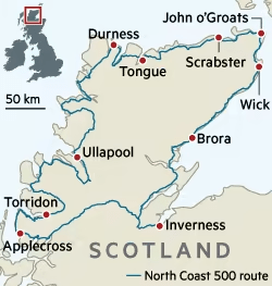
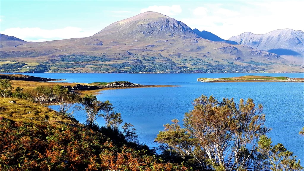
The North Coast 500 is a 516-mile scenic route around the north coast of Scotland, starting and ending at Inverness Castle. The route meanders along country roads through some of Scotland’s most dramatic coastal scenery.
This route offers the freedom of the open road in addition to endless opportunities to take in stunning vistas, hike endless beautiful landscapes and mountains, and wild swim in the sea, an abundance of lochs, pools and waterfalls.
Also known as the NC500, the route was launched in 2015, and links many of the best destinations in the North Highlands of Scotland. So, buckle up, and come with me for the road trip of a lifetime.

The Journey North … Part 1
25th/26th August 2022
‘The Beast’ for those of you, who have not yet been introduced, is my VW T5; she is big, black and beautiful. We have shared many adventures together and I love her very much.
She was packed and MOT’d over the course of the week, and we were good to go. I fled the confines of my work desk, ASAP Thursday evening, with a loose plan to drive as far as I could, before sleep prevented further travel.
From my home, near Marazion, Cornwall, I managed to drive a good 5hrs. I probably missed some better parking spots, blink and you’ve zoomed past them. It’s not always easy to stop and turn around again on main roads.
Anyway, instead of a nice scenic country locale, I found myself in a lay by in Walsall, round about midnight. But… at least I didn’t end up on the notorious Cannock Chase, the Midlands Premier dogging and drug central. A reasonable night’s sleep was had, no disturbances, and I set off at the crack of dawn on Friday, to beat the bank holiday traffic.
Tip for Road Trippers – join English Heritage and you can use their sites as pit stops on your journey. Rather than motorway services, it’s a good way to take a break, and see interesting places at the same time.
Pits stops on route included:
- Whalley Abbey, Lancashire, a beautiful peaceful Abbey and gardens with a nice small café and toilets https://www.visitlancashire.com/things-to-do/whalley-abbey-p7141
- Lowther Castle & Gardens, Lake district, a private castle but discounted with English Heritage Membership, also has café and toilets https://lowthercastle.org/
The beast took a nasty and expensive flying projectile, straight in the face, on the M6. It hit with such force, that I thought that the windscreen would shatter. But, she escaped with two nasty chips, that caused me to hold my breath over every pothole, just in case it cracked further.
I was aiming to get to Loch Ness and Inverness (Start of the 500) on Friday night. But I guess I had too much fun on route, there were a couple of traffic queues and there was Glasgow!!!
You need eyes in your ears and arse to get through there intact, it was terrifying. The M8 Eastbound and Westbound, between junctions 15 and 18, was restricted due to road works, and I found myself in the middle of Glasgow stuck in traffic.
It chucked it down with rain for an hour or so, but I made Loch Lomond before dark and found a perfect lay by on the shore. Supper was a left over cheese and chutney sandwich. I sat on the beach and watched the sun set over the Loch and the Trossocks. Rather than an orange/red, the sunset here is a strange eerie blue… but still beautiful…
There was a tent on the beach and other vans for company, and I had a peaceful night’s sleep
Today’s road trip tuuune https://youtu.be/n2MtEsrcTTs
The Journey North Part 2
27th August 2022
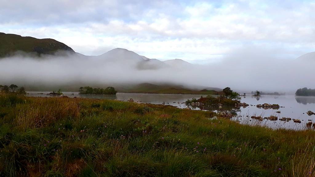
I woke early and refreshed, after the previous day and half of hard driving, and hit the road again at 7 am. I still had 3 hrs of driving to get to Inverness, gateway to the North Coast 500. I was straight into some magnificent vistas, and found myself already thinking, that I wish I’d parked here last night, I could have paddled on that Loch, hiked up that mountain etc etc.
But, you can’t be everywhere at once … and you can’t always get what you want, ‘but if you try sometime, you’ll find, you get what you need’… I’ve learned over the years to trust in the journey…
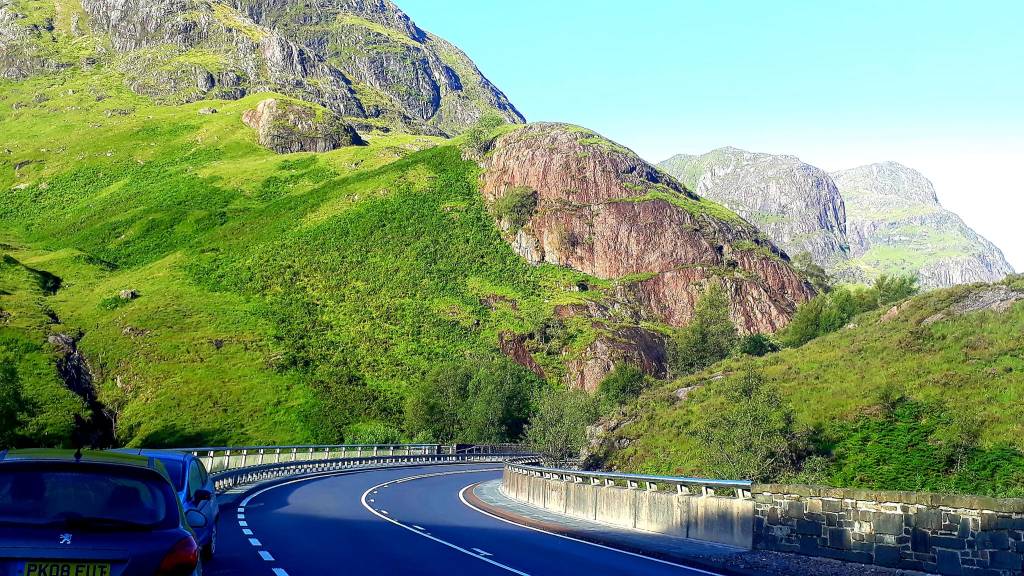
Immediately, I’m in trouble with the locals, I’m rubber necking at the views, driving like a tourist, and cars are flying passed me on hairpin bends. But I don’t care, I’m in my zone, I’m in awe of the misty mountains, the rising sun, and the vastness of the landscape, here I can breathe, I am free at last…
Shortly, I find myself in Glencoe, towering Ice Age landscapes all around me. Hikers everywhere, I want to join them, my tribe… but I have many miles to go, and I’m committed to this road trip. I stop for breakfast, in a lay by full of camper vans, with a breath-taking view in front of me.
I’m just about to spoon muesli into my mouth, and the sound of bag pipes echoed across the land, I felt a lump in my throat, my eyes welled, and my heart soared with the plaintive and haunting sound. I thought it was playing on someone’s stereo, but it was a real piper. Everyone stopped, it was surreal, in this ancient landscape, a bunch of strangers, just silently listening…
There were so many experienced mountain walkers and climbers here, the elite, the thrill seekers, a different breed. It makes my little walking adventures look tame in comparison… there’s always people crazier than you.
On I drive, next stop Fort William, for a quick pee, and a look at the Old Fort. Sadly, little remains of this once important place. Even sadder, metres away, stood a huge Morrison’s store, a McDs and an industrial Estate, an ugly, noisy concrete juxtaposition at the foot of Scotland’s most famous Nevis range.
It was too depressing for words, and I wondered what the ancestors would make of all this. I look longingly at the majestic summits and drove on. Thirty minutes away from Loch Ness, google maps diverted me off the main route onto wonderfully undulating single lane roads – clever thing. This road takes the high route, right next to Loch Ness, with amazing views. And if you take those humps at speed, it feels like you are flying …
There are many warnings in guide books, blogs and websites about the single lane roads here, but… if you have driven in Cornwall, Wales, Ireland or in fact anywhere rural… you will be fine
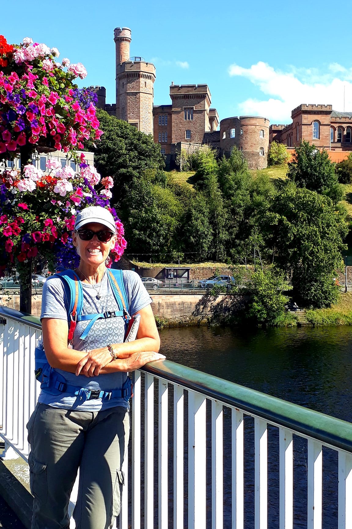
I finally reached Loch Ness late morning, I didn’t find a place to paddle board, but there will be plenty of opportunities? And I arrived in Inverness just in time for lunch at the Botanical Gardens (recommended) and a walk around the old town. But the noise and crowds were messing up my newly acquired Zen.

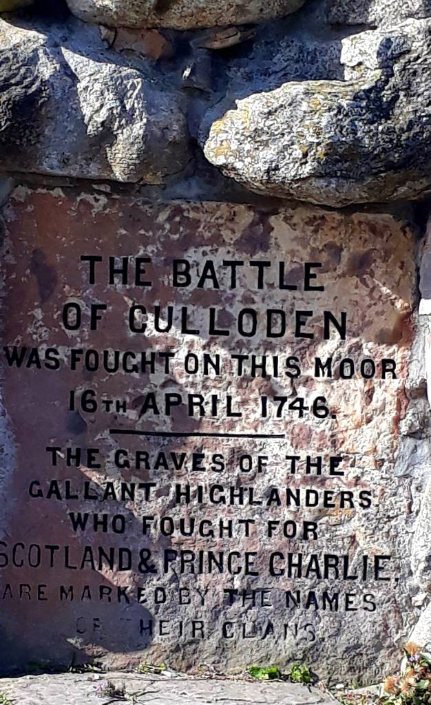
So, I headed for Colluden Battlefield, a sombre and thoughtful place, and important War Grave. I spent a good hour or so there. It’s described as “Powerfully emotive and atmospheric battlefield, where the 1745 Jacobite Rising came to a tragic end” … and it really was.

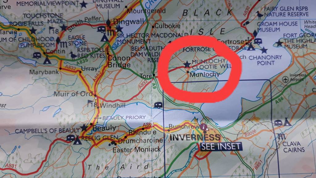
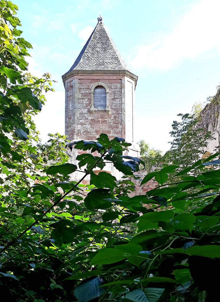
Feeling a bit bummed off after that, I decided to start the NC500, and headed for Beauly. The first town on the route, with a lovely old Church and Priory. I parked up for the night overlooking Munlochy, on the Black Isle. It’s not an island at all, but a peninsula, surrounded on three sides by water. The Cromarty Firth to the north, the Beauly Firth to the south and the Moray Firth to the east.
To be explored tomorrow along with the Pictish Trail
Today’s road trip tuuune https://youtu.be/jv9sDn_2XkI
28th August 202A
Day 1: Inverness – Beauly – Dingwall – Tain – Dornoch (with the Black Isle 93 miles)
Area: Inverness-shire, Easter Ross, and Sutherland
I’m already on the Black Isle, after passing through Beauly last night. I stopped at a well known parking spot (park4night app) alongside a motor home, and three campers. I’m sandwiched between the giggling young couple and a family with two perpetually grizzling children…
The parking is set back from the road, which is quite busy at all hours, considering its location. I wondered where everyone was going? I had read reports on park4night of locals zooming past honking their horns, I did hear some of that. Lord knows why, its waste land, with no houses nearby.
Anyway despite that and my noisy neighbour, I had a good nights kip, had a leisurely breakfast this morning, and planned to hit the Pictish Trail.
However my plans were soon thwarted, as my first stop Groam House Museum, Rosemarkie, didn’t open until 1 pm. Bugger, the Pictish Trail was the only reason I detoured off the NC500. My Zen was starting to waver… so I entertained myself with other recommendations on the Isle.
Chanonry Point was rather cool, between Fortrose and Rosemarkie with views across the Moray Firth to Fort George. Apparently dolphin activity here is influenced by tidal conditions. They can be seen at anytime (or not at all!) but the best time to see them is usually on a rising tide. Around 1 hour after low tide, the tide turns, and dolphins start to chase fish in.
So, how to spot dolphins, first walk toward the large crowd of people on the beach, watch the birds circle and the fish jumping… and wait………. alas no show…
Next the Fairy Glen Waterfall… I should have known from the title, anything that starts with Fairy, is usually disappointing, plus there’s been a prolonged drought. If you happen to be passing and fancy a pleasant woodland walk, great, but I wouldn’t go out of your way just for the waterfall
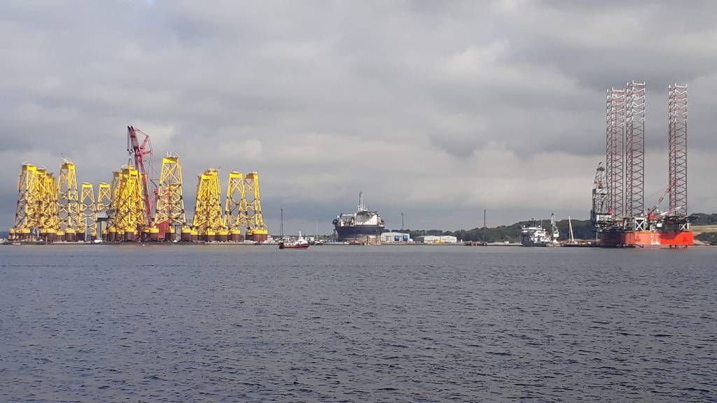
Next the ‘highly’ recommended, town of Cromarty. Once an important harbour in the 1700s. More recently associated with the North Sea oil boom, its used as service and construction yards. And there’s a string of rigs moored along the length of the Firth.
I was now wondering “how did I get here, my god what have I done” more wasted diesel, my Zen trickling away like grains of sand…
I considered taking the Car Ferry across to Nigg, so I could avoid the trip back up the Black Isle and the drive back down the other side of the Cromarty Firth. But it only carried 2 cars and 12 people, and would be £16 for the Beast
So I made the best of a bad detour, paid a visit to the ruined Gaelic Chapel and sat on the sea wall to eat an expensive toastie and coffee. Then headed back to Groam House Museum
The car park, empty this morning, was now rammed with motor homes. I hate motor homes, chugging up the streets everywhere. My Zen now in tatters and steam coming out of my ears. But, I found parking on the sea front, and discovered that Rosemarkie has a lovely beach and cafe restaurant. I wish i’d stayed here this morning instead of wasting diesel…
Groam House is a Museum of Celtic and Pictish Art, all found in the local area. It was well worth the wait, it was just opening as I arrived, and the curator was really helpful and informative.

My advice, if you want to visit the Black Isles take an extra day. There are lots of woodland trails to hike or cycle. Spend some quality time at Chanonry Point, Rosemarkie and of course The Groam House Museum.
I was now against the clock, trying to get to the other Pictish sites before they closed. I drove like the wind, off the Black Isle toward Dingwall (NC500). Thank god the roads are fast and straight. Dingwall Museum was shut… but on route to The Eagle Stone, Strathpeffer, I saw a Red Kite whirling above, a good omen …
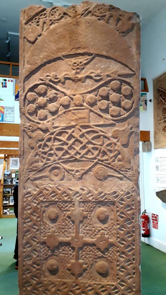
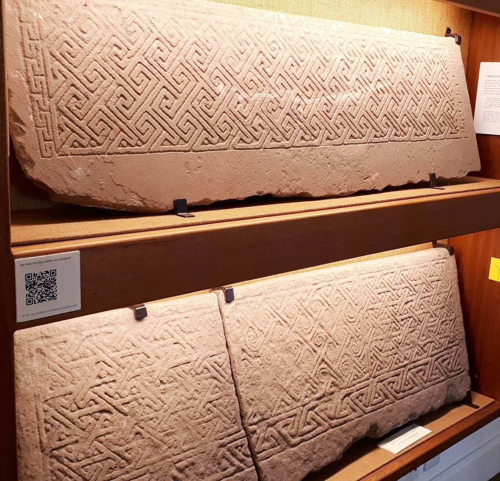
My fortune was changing, I made good time to the Nigg Stone at Nigg Church, Tain, which was pretty impressive. And I screeched into the Tarbet Discovery Centre at Portmahamack 20 mins before closing. Not only did the curator not charge me, she gave me a whistle stop guided tour, and then directed me toward the other local stones.
Housed in the old parish church of Saint Colman, Portmahomack, was also the site of a very early Christian monastery. Possibly founded by Saint Columba in the late 500s. It has a fascinating and gruesome history in addition to displays of Pictish sculptural pieces, including a famous menagerie of Pictish animals, mythical beasts, and intricate geometric spirals
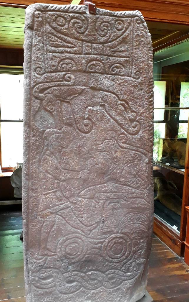
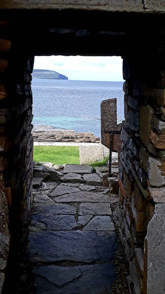
A hectic day was brought to a close by a drive up to Tarbat Ness Lighthouse, where I was going to stay the night. But park4night directed me to a better spot, on route to my final Pictish sites, the Hilton of Cadboll Stone and the Shandwick Stone, sadly now encased in glass due to vandalism
I dropped anchor for the night, right on the beach at Shandwick/Hilton, there are toilets, a water tap, and the locals welcome parking here… my Zen was restored
I ran out of time to get to Dornoch, but its only 30 mins away …
Today’s Road Trip Tuuune – https://youtu.be/5IsSpAOD6K8
29th August 2022
Day 2: Dornoch – Brora – Helsmdale – Dunbeath – Wick (62 miles) 78 with John O’Groats, which I gave a wide birth.
Area: Sutherland and Caithness
It was gone midnight by the time I snuggled down, blogging about today’s Pictish wonders took quite a lot of research. But I had a glorious night, lulled to sleep by the sound of lapping waves, and Oyster Catchers calling.
I woke to quite an overcast morning, and I contemplated a swim, but early dog walkers were wrapped up for winter, but I desperately need a shower. So, off I went to test the water, it was not too bad, so I dashed back to the van to get my cossie and then dove straight in. The water was a bit brackish, but it was lush and invigorating, a strong start to the day.
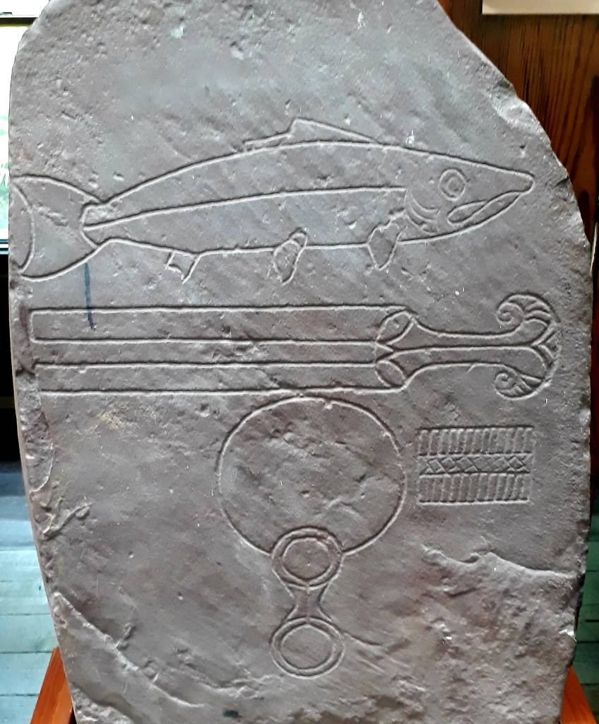
I set off 9 ish back onto the Pictish trail, and visited the sites at Edderton. Clach Biorach is a large carved stone supposedly marking the Grave of a Danish Prince killed in a battle with the local Pict’s. A large crow was sat upon the top, but flew away as I approached, then circled above crowing… It was too early to decipher messages from Odin, but I’m seeing it as a good omen.
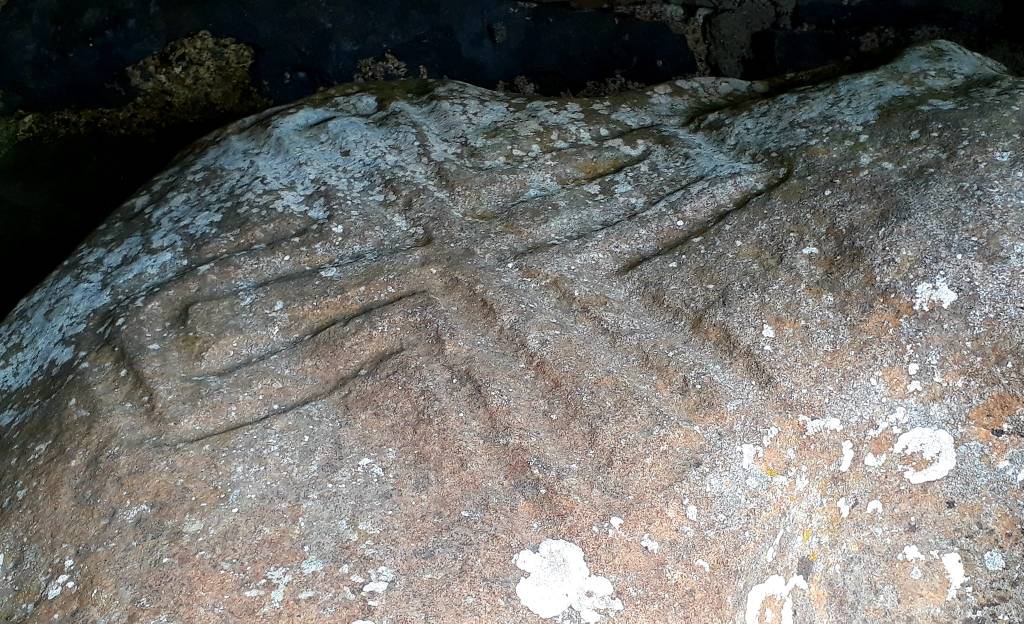
The stone has clear Pictish carvings of a fish (salmon) above a double disc and Z-rod. The Edderton Stone Circle, across the road, is 3,500 yrs. old
Further down the road is Edderton Cross Slab, a Class III Pictish stone in the old graveyard. The red sandstone, has an elegant Celtic cross on one side. On the upper half of the other side, is another cross standing on a semi-circular base or arch, with a horseman below, Underneath this, are three carved horseman, that may commemorate a battle between Pict’s and Vikings. Cut into the stone by some ancient hand.
Other than incredible Pictish sites, I visited an abundance of treats today. I don’t think I could have packed anymore in if i’d tried. The theme of this trip is running short of time “If only I could have forever”
Next on my list, Dunrobin Castle and Gardens. If you like opulence, this is the castle for you, it was not my cup of tea, I like older castles. But I was really here for the museum and the Pictish collection.
The museum has two of the finest stones, the Pictish symbol stone class 1 and a magnificent cross-slab from Golspie. Both are carved with enigmatic symbols and designs unique to the Picts.

Also as luck would have it, I arrived just in time for a falconry display. I became an accidental part of it, when the Peregrine’s flight path took him straight passed my head twice. I heard the whoosh and felt my hair move… wonderful… such mastery of the sky.
The landscape so far today, has been low moorland, bracken, gorse and the ‘Bonnie’ purple ‘heather’. It’s sheep country, with the great expanse of the North Sea to my right.
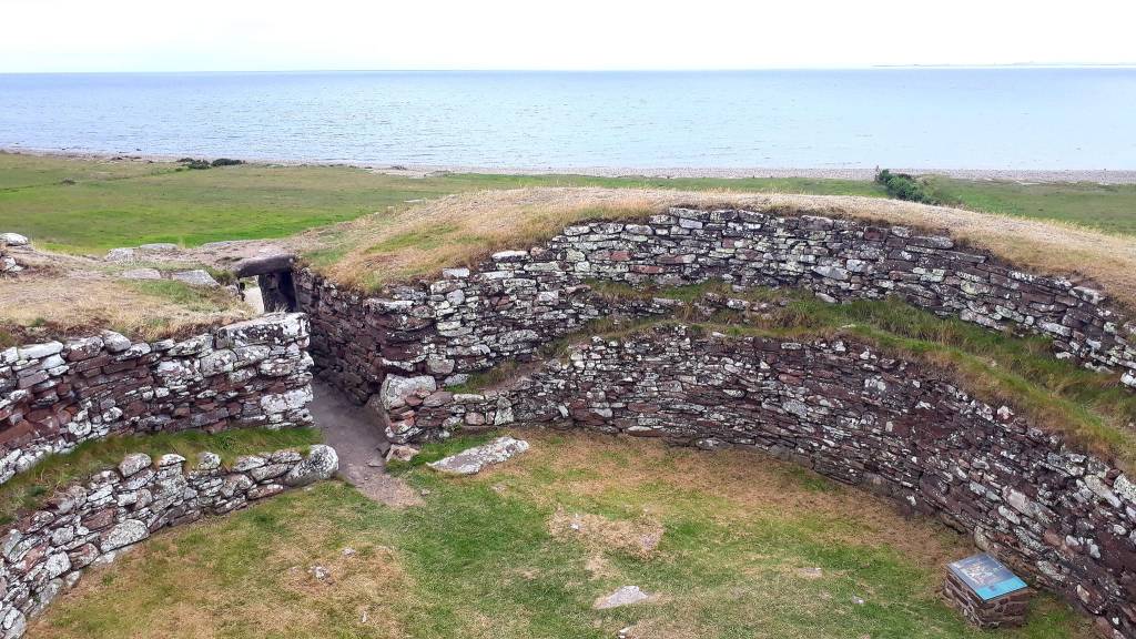
There was none of the spectacular scenery of the previous days… it peaked too early. But this is why they suggest doing this coast first, it gets better as you proceed North and West. But, I certainly got some exercise in today, after visiting the castle, I visited Carn Liath (broch), and Dunbeath Broch and Heritage walk.

Sadly I didn’t get to finish the heritage trail, I walked for a couple of hours, but still had a lot of road to cover. This would have been a nice afternoons walk, so If you visit, make sure you allow plenty of time to enjoy it.
Back on the Pictish Trail, I hunted down the elusive ‘Lybster Stone‘, hidden away at the side of a church. Lybster has the widest high street I have ever seen in a tiny town, and it had more than one church.
Eventually I found it, beside an unassuming Church, after driving up and down the high-street several times. Tucked away under a flagstone shelter, is a large boulder stone which has been inscribed with a simple double outline cross. It shows the influence of Christianity on the Pictish people of the far north, and is also linked with local superstitions.
Next on route is Whaligoe Haven, one of the most remarkable harbours to be found in Scotland – surrounded on three sides by 250 feet cliffs, and is reached by the Whaligoe Steps which zig-zag down the cliff.
More castles and cliff top walks to bring the day to a close… first, the Castle of Old Wick. It stands on a spine of rock projecting into the North Sea, between two deep, narrow gullies. Sadly the castle is fenced off due to erosion, but the scenery is worth the cliff walk. You can park overnight here in the large car park for a fee, I moved on, as there were still sights to see…
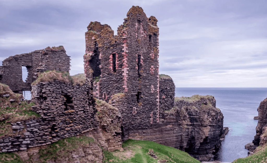
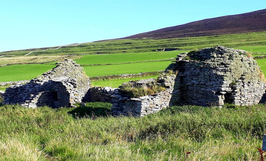
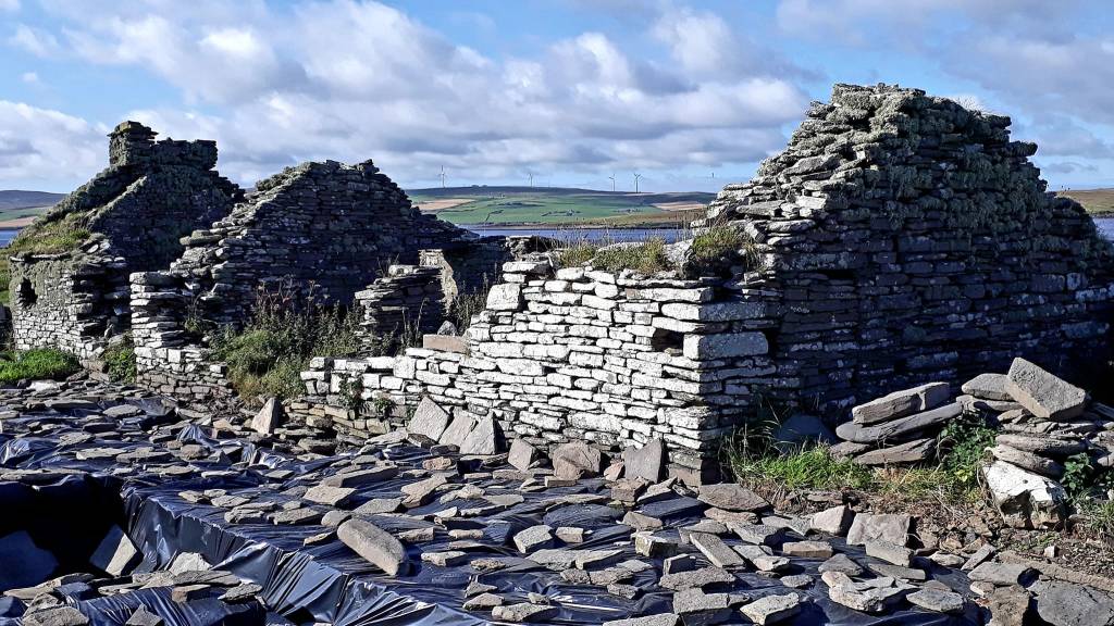
Now I’m at the end of the world at Noss Head, where I will park up over night, but first a walk down to Castle Sinclair Girnigoe. Which is a complex of ruined stone structures built and modified over a 200-year period by the Sinclair earls of Caithness.
It was a dramatic sight, with the back drop of the sea and the patchwork of pink sandstone, that mirrored the setting sun. It was a fitting and romantic end to the day.
The small car park near the lighthouse is £3 for 12 hrs, motor homes are £10. Quite right too, there are two here this evening, taking up at least two spaces each. The one beside me, had its engine running for an hour, lights on… why?
After patiently choking on their diesel fumes, I asked them to switch it off… totally messing with my Zen…
Today’s road trip tuuune – have you guessed what it is yet? https://youtu.be/6c75cOL0G8I
RIP Bonnie ‘Heather’ Highlander
30th August 2022
Day 3: A last minute decision, which nearly didn’t happen…
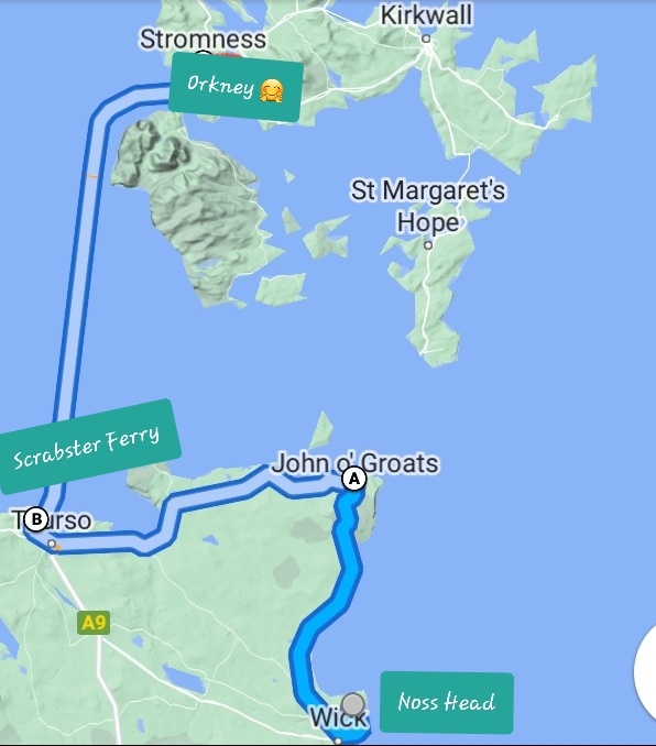
Part 1: eeeek off to The Orkneys I go…
I got a dash on this morning, when it slowly dawned on me that I could get to Orkney from here. The ferry was full from John O Groats, and the morning one was full from Scrabster, so lunch time it is then…
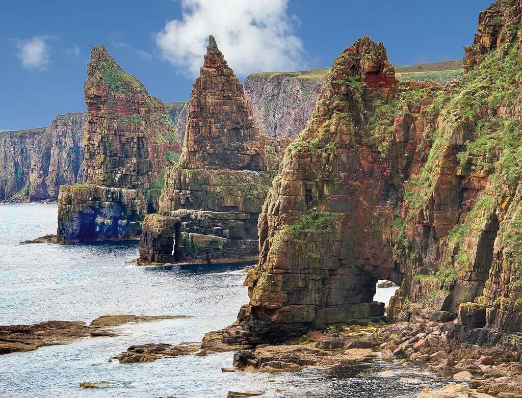
I whiled away the hours visiting local sites on route to Scrabster Ferry Terminal. The Duncansby stacks are a wonderful sight first thing in the morning, and it’s a great place to watch nesting Fulmars. They will fly really close to you and lock eyes with you, they are masters of the sky…
The driving is easy and pleasant, in the far north, gently undulating roads through moorland and sand dune systems. Reminiscent of a cross between Dartmoor and Hayle Towans. I think I saw a Hooded Crow today, the last time I saw one was in Ireland. The starlings are also starting to murmurate… winter is coming…
Speaking of Ireland, a lot of the ancient monuments and places here have Irish names. This is because Gaelic speakers crossed the Irish Sea 1,700 years ago and became the Scots – so named by the Romans. This blew my mind – I did not know that – ultimately there was conflict with the native Pict’s
Tips for the trail, google stuff well before you visit to check it’s worth the miles, diversions are costly (Fuel). Also a lot of places don’t open till Tues/Wed and then not until 10 am. So, if like me, you think you can pack a lot in if you start early, check before you set off and plan ahead
There was much I could have seen on route this morning, Castle Mey, and the Broch Centre, formerly the Northlands Viking Centre, but they were closed. So, I stopped for a quick visit to Old St Peter’s Church, Thurso. It was fenced off due to restoration work, so I could only see the outside.
Enjoyed a morning coffee at ‘Caprilla’ while I waited for the Ferry… sooo excited. The people were really nice there, very welcoming with every sentence punctuated with “No Bother” I guess it’s like No Problem
Part 2: Orkney continued …
Well I can’t believe I’m on Orkney, no idea why I hadn’t thought of it sooner, I love it when I even surprise myself. What an amazing day it’s been
The sail over was lovely, great views of the island cliffs and Old Man of Hoy, as we sailed into the Islands. The Orkney Islands lie off the northern tip of Scotland, where the North Sea and the Atlantic Ocean meet. The Islands have dangerous tidal streams, and as we sailed into the Hoy Sound for Stromness, the water appeared to be boiling.
Fulmars (Stumpy Albatross) followed the ship for the duration, some flying quite close to me. Their steely black eyes locked to mine. Others, their wings barely skimmed the surface of the sea, as they glided effortlessly above, mesmerising
Its as cold as a Cornish winter up here, I had to put on another layer, and tuck my vest in my pants… the locals are in T shirts. The landscape of the island is largely treeless, deforested long ago by ancestral people, which ultimately led to their demise. Think Easter Island…
Lots of moorland, grazing sheep and cows, the land an almost iridescent green. Oddly I’ve not seen a single highland cow on this trip so far. Domesticated breeds seem to be favoured.
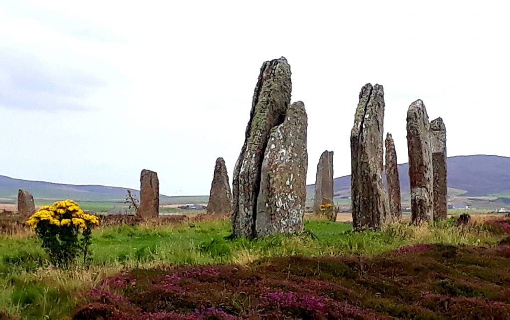
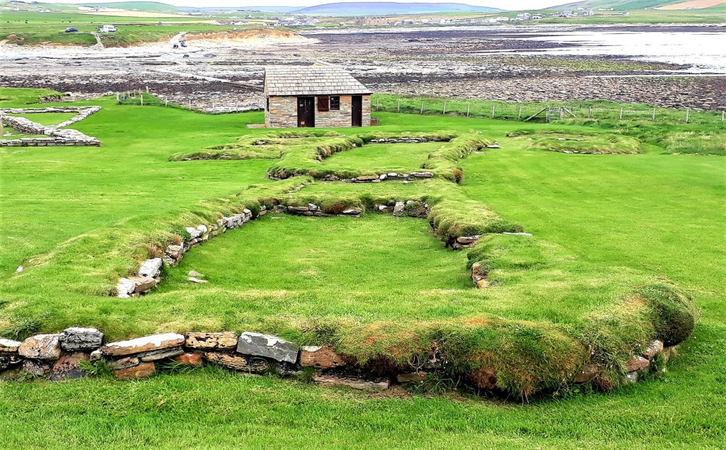
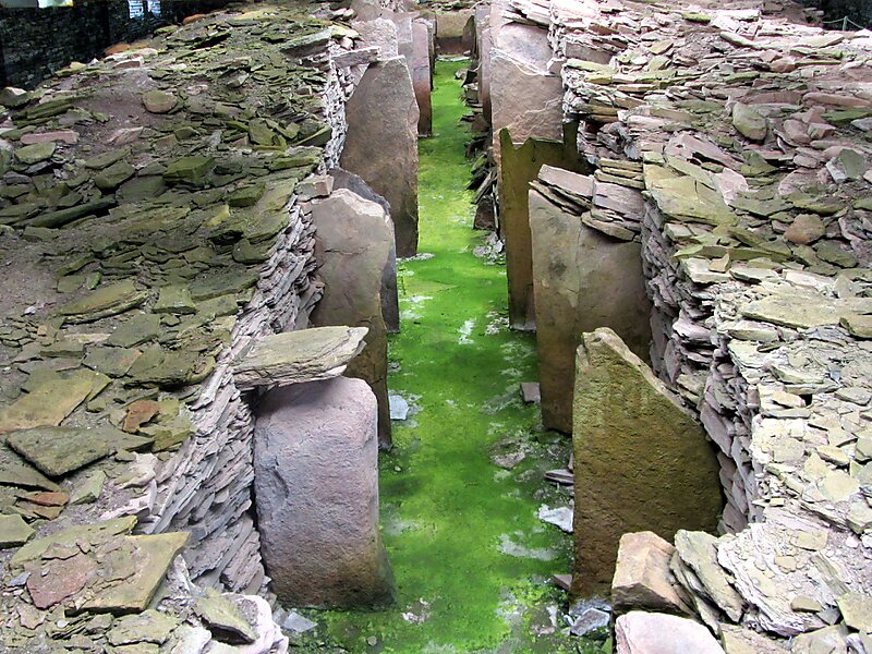
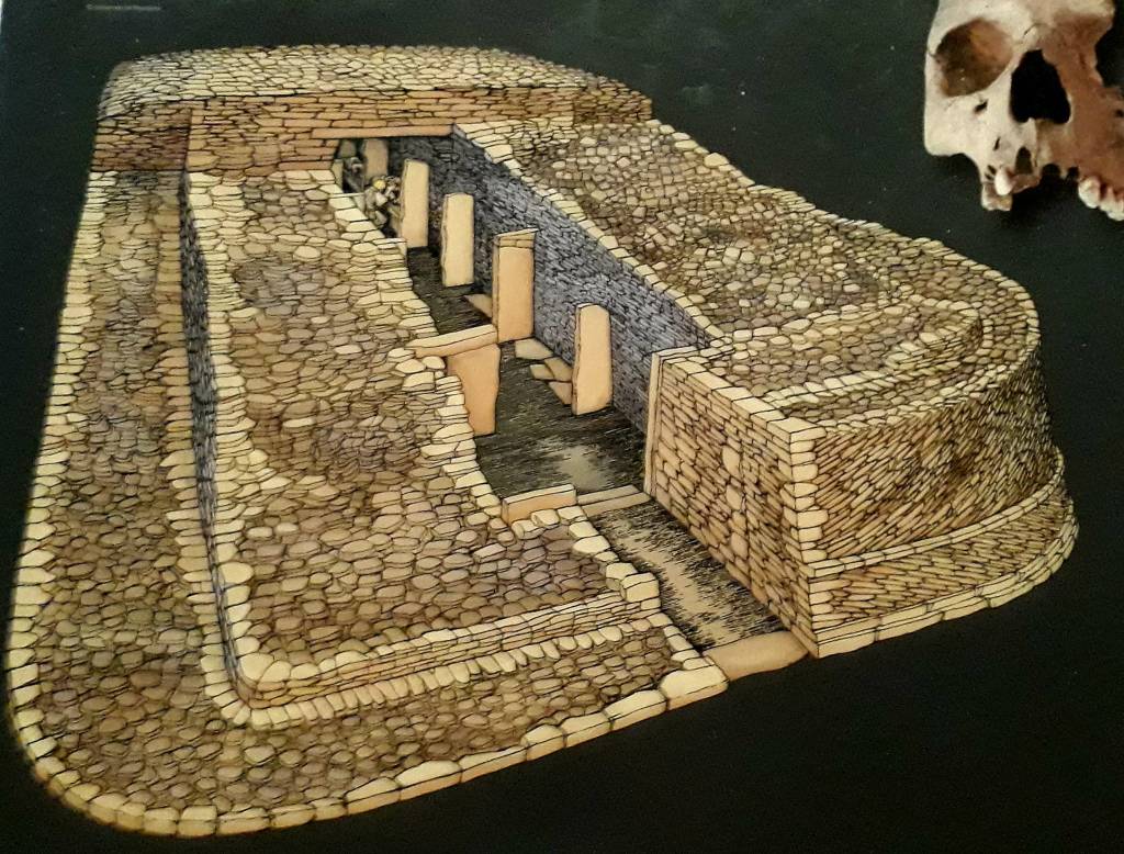
From the ferry I headed off, in the beast, for Skara Brae, stopping at Unstan Chambered Cain on route. Which was my first crawling on hands and knees experience of the day. Then the impressive Standing Stones of Stenness, towering pillars, wafer thin in comparison to their height. Looking up at them was disorientating, they looked like they were tipping over and would crush me in an instant

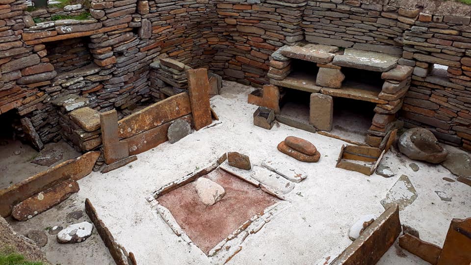
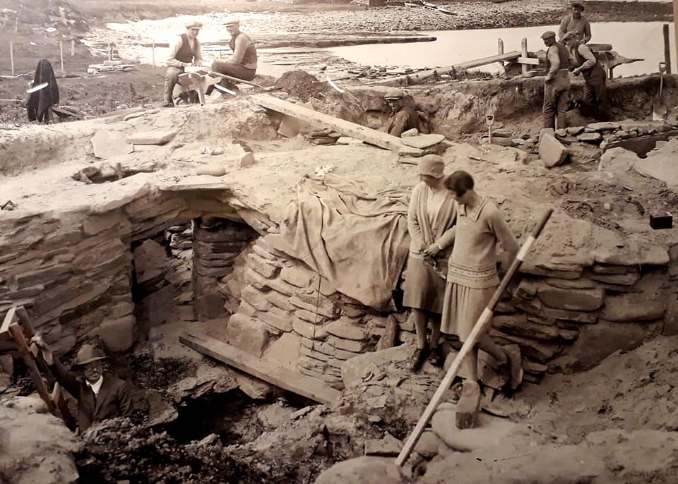
Skara Brae is a UNESCO site, and was hidden in the dunes and uncovered by a winter storm in 1850, that caused widespread damage and over 200 deaths.
Following the storm, locals found the outline of a village with ten clustered houses, made of flagstones, and earthen dams. The houses contained stone hearths, beds, and cupboards. A primitive sewer system, with “toilets” and drains, that carried waste to the ocean. Water was used to flush waste into the drains… pretty modern really…
You need to book prior to your visit; it was touch and go that I got in at all. I was trying to make a booking, whilst on on the ferry, and the site kept crashing.
Skara Brae is a pretty impressive place, it has a visitor centre, with an exceptional replica of one of the chambers, that gives you a feel of what it must have been like to live here in Neolithic times.


Skaill House, a historic manor house, that overlooks the neolithic site is included in the ticket; cost me a fiver as an English Heritage Member
Due to my late sailing, I “was out of time” to see other ‘entrance fee’ sites, so I entertained myself by visiting all the free ones, an ‘ancient site binge’, four in total. Not as crazy as it sounds, they are all on the same route to Kirkwall, where I parked up for the night.
All the sites were fascinating, many of the tombs commonly have ‘Embellished Entrances’ where incised markings have been found. We will never know what they mean, but they suggest “important thresholds within the structure of the tombs”.
Its worth having a read of the separate links included to discover their compelling history
The Ring of Brodgar Stone Circle & Henge – a stunning site and atmosphere, especially in the evening with fewer tourists

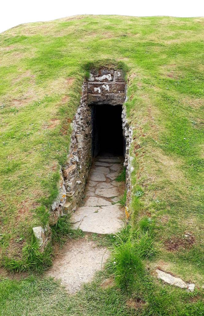
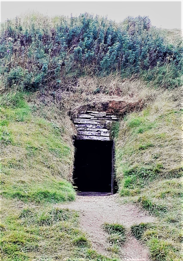
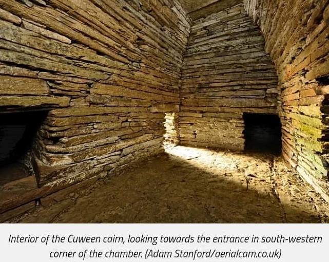
Cuween Hill Chambered Cairn – nothing to look at from the outside, but…
Rennibister Earth House – slap bang in the middle of a farm yard, so I didn’t feel I could weasel my way out of going inside, fully committed to the challenge
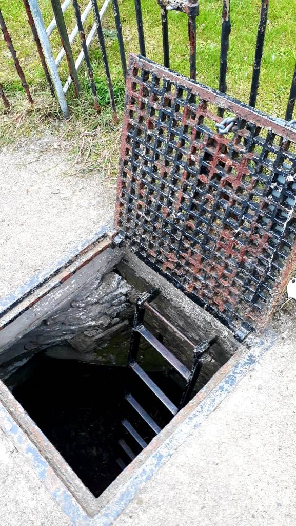

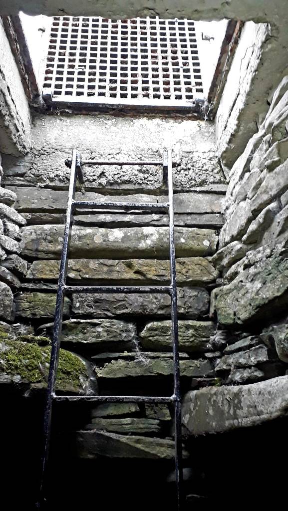
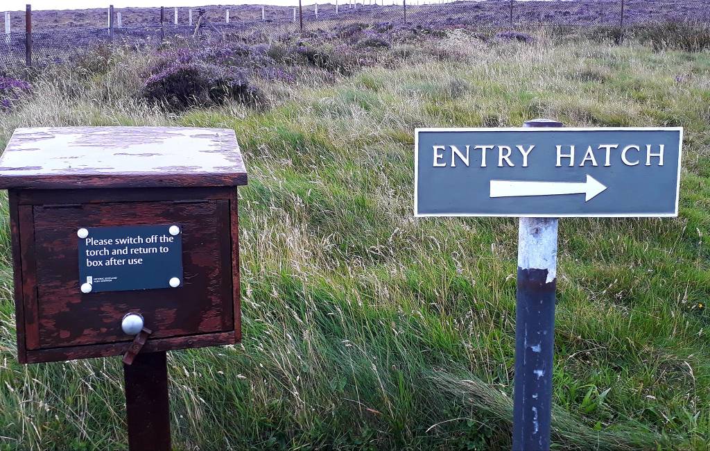
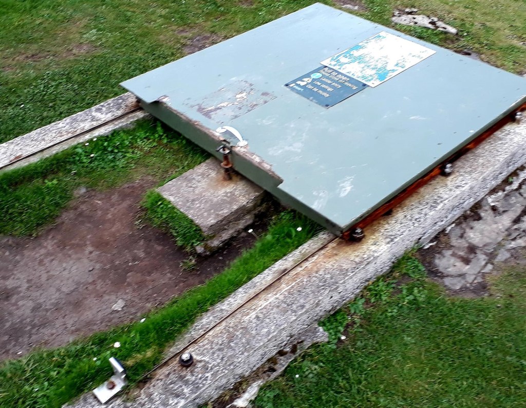
Wideford Hill Cairn – quite the hike to this one, and a scary hatch, but worth the the long walk and scramble

I will sleep like the ‘dead’ after all that, I now have until 15.45 pm tomorrow to see more. I’ve booked a ticket for Brock of Gurness, no tickets available for Maeshowe until Sunday, but I’m going to try and blag my way in, and Ness of Brodgar looks like you can rock up?
Until tomorrow…
Today’s Road Trip Tuuune – https://www.youtube.com/watch?v=DCI6-HD88QM
31st August 2022
Day 4: Orkney
I ‘aimed’ for a more relaxed day today… I have come to realise that I suffer with severe FOMAS… Fear of Missing Awesome Stuff. I’m like the athlete of the travel world, a marathon adventurer. It’s hard to slow down, you have heard the term seize the day… I want to see it all, do it all, and experience it all. It’s not very Zen, but I could die tomorrow…
The day started with a bacon butty and coffee, a strong start, a food van had appeared in the car park in the early hours. Then I set off for the Brough of Bursey, I had considered driving up early, as the tide was low 6.30 am, I could have walked over to the island, but I was tired and there was bacon… so…
I arrived 8.30 am to a most beautiful and tranquil spot. Vans were parked here, curses… I had an attack of ‘if only’s’ and ‘coulda’s’. If only I’d come up last night, I could have parked up for the night, gone out on my paddle board, had a snorkel, with the other intrepid people swimming here, I could have walked over to the Viking Village and spent the evening there…
But, you can’t know, what you don’t know, until you know… and I’d booked a ticket for 10 am to visit Brock of Gurness. I considered a quick dash across, to the island, but the tide was coming in fast, and I wanted to enjoy my time over there, so I headed off. I knew before I left this morning that I wouldn’t have time to get over there, but I felt strangely compelled to drive there anyway…
As it turns out, I could have been late for the Broch, there were only a few people there. It was then that I decided, I needed more time, so after a lengthy hold on the phone to the ferry company, I extended my stay on Orkney for another day, so I could fully Zen.
Next, I had my first encounter with Orkney Midges, tiny little biting bastards, with big teeth. Not a breathe of wind here, and they love that, I got eaten alive, despite ‘Smidge’ they laughed in my face and continued their savagery
Brock of Gurness was in a beautiful spot, right on the shore. The ancients knew a thing or two about location. It’s a pretty big and complex settlement.
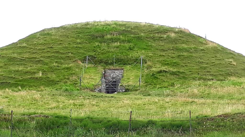
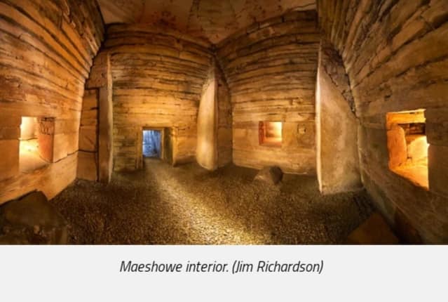
My next destination, Maeshowe, it was fully booked online, until Sunday, but I thought I would wing it and see. It turns out the site is now kept locked and its guided tours only, hence the booking system. But, I managed to blag my way onto the tour, made easier as I was solo, they were turning others away.
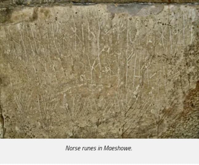
Maeshowe is well worth the visit, just for the Viking graffiti, so funny and very human. A bunch of Vikings taking shelter in an old tomb, with nothing better to do, wonderful. The 30 inscriptions found inside, make it one of the largest, and most famous, collections of runes known in Europe. You wouldn’t know they were there, they are only visible by torch light.
Here are some of the translations:
- “Thorni f*cked. Helgi” (the official guidebooks usually tone this inscription down)
- “Ingigerth is the most beautiful of all women” (carved beside a rough drawing of a slavering dog)
- “This mound was raised before Ragnarr Lothbrocks her sons were brave smooth-hide men though they were”
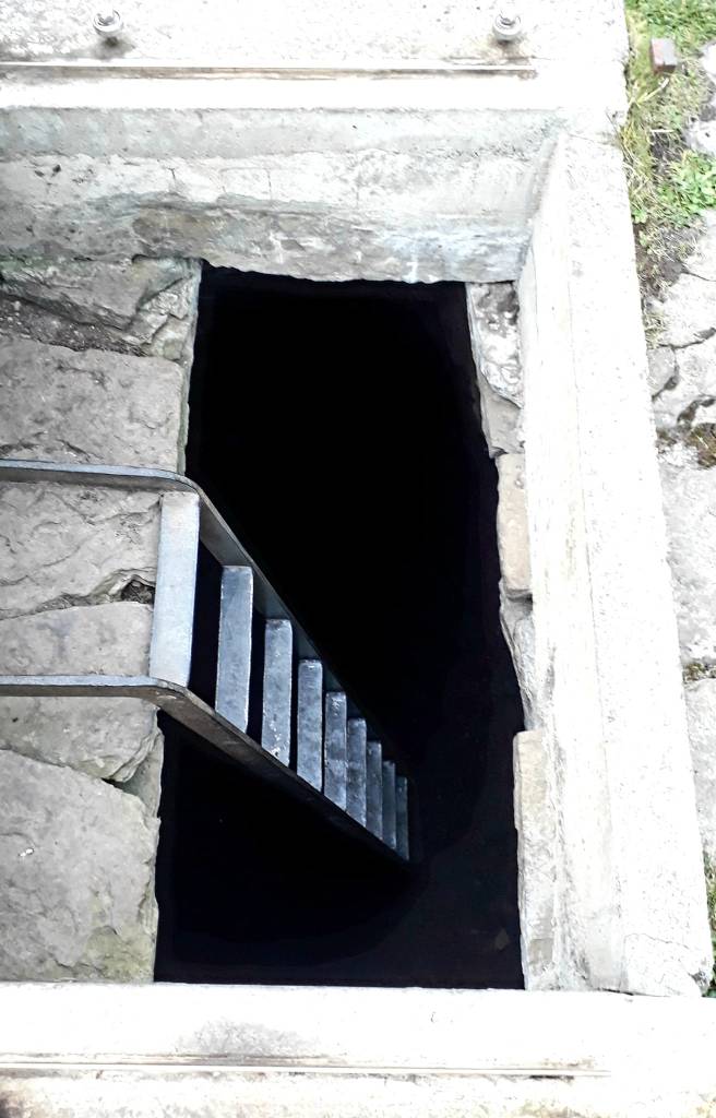
No photographs allowed inside the tomb, so if you want to read more, click on this link. Below is the only picture I could take… its locked up tighter than the valley of the kings
On route back to Kirkwall, after an extraordinary morning, I drove through ‘Northman Town’, nothing to see, just a normal village, but I pondered the history of the name and couldn’t find any information on it.
The Ness of Brodgar is an archaeological site covering 2.5 hectares between the Ring of Brodgar and the Stones of Stenness. According to the Orkney Facebook Hive Mind, it was closed down for the winter and there was no access. So I spent the rest of the day, bimbling about Kirkwall
I had a proper lunch stop, soup with bannock – Scottish/Irish Soda bread, very tasty. Then wondered around Bishops Palace and Earle’s Palace, and St Magnus Cathedral
The Cathedral, known as the ‘Light in the North’ was founded in 1137 by the Viking Earl Rognvald, in honour of his uncle St Magnus. It has a fascinating history, of Viking treachery, martyrdom, dishonor and murder… all documented in the Orkneyinga saga.
And last but not least, a visit to the free Orkney Museum, which is like a little Tardis, it just keeps on giving. It tells the story of Orkney, from the Stone Age, to the Pict’s and Vikings, right through to the present day. Feeling very weary now, after a two day ancient history marathon, I headed back to Brough of Birsay, where I would spend my last night on Orkney.
Such a beautiful place, crystal clear waters, fantastic geology, very reminiscent of the Bude coast (Cornwall). Lots of hermit crabs, scurrying about in rock pools, my favourite rock pool inhabitants. The white sands are clean and made of tiny crushed shells.
So, I found myself walking on a Viking beach, toward a Viking Village on a tiny island. It was so easy to see why ancient people settled here, it’s sheltered, there are great fishing waters and it’s a safe harbour. The village has an interesting history, and has been inhabited for 1000’s of years by stone age people, the Pict’s and the Norse


It was my favourite place so far, so peaceful, and I found it strangely difficult to tear myself away. I sat over there for ages, soaking it all in, birds calling all around, I had finally found my Zen. Without too much imagination, I could see Long Ships arriving at the shore…

According to the Orkneyinga Saga, Brough of Birsay was the seat of Thorfinn the Mighty (1014-1065), a powerful lord who became Earl of Orkney and controlled all of Shetland, Orkney, Caithness, Sutherland and the Hebrides.
I didn’t snorkel or paddle in the end, when I arrived the tide was a long way out, and by the time it was sufficiently in, at 8 pm, it was really cold. So I spent the rest of the evening reflecting on my adventures so far, and watching the sunset behind a Viking Village, from a Viking beach, it doesn’t get much better than that.
Then I drifted off to sleep, listening to the sea, the oyster catchers calling, dreaming ancient dreams, under the watchful protection of the Lighthouse, magical…
Road trip tuuune of the day – https://www.youtube.com/watch?v=0p_1QSUsbsM
1st September 2022
Day 5: Island of Rousay
I woke early to a beautiful sunrise, and had one more walk on my Viking Beach, then said a sad farewell to this beautiful place. I had one more place to visit before heading back to mainland Scotland this evening… A trip to Rousay…


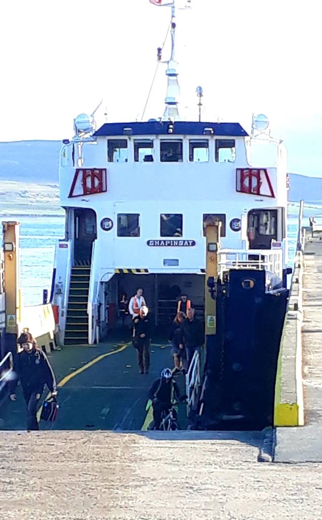
Rousay is a small, hilly island 1.9 mile north of ‘Mainland’ Orkney. Awarded Site of Special Scientific Interest status in recognition of its outstanding natural habitats. Rousay is also known as the “Egypt of the North”, due to it’s renowned archaeological sites – over 160 to be exact and more are being discovered all the time.
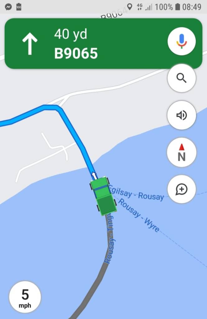
It’s a 20 min ferry ride from Tingwall, and it doesn’t mention this in the brochure, but you have to reverse onto the ferry… that was fun. I wondered why locals were parked the other way round at the harbour.
The ramp onto the tiny ferry, drops away steeply, so visibility is poor. Despite reversing the beast carefully and slowly down the ramp the ferry guy was beside himself, shouting “look at me, look in your mirrors; if you don’t watch me you will hit something”. Jesus, calm down Karen, the only thing I’m gonna hit in minute is…
Aside from that, we all squeezed on like sardines and it was a lovely voyage over, so exciting.

There’s only one circular road on Rousay, and all the main archaeological sites are on route, so you can’t get lost. I had a morning to visit all the sites open to the public, which was plenty of time, so I cruised around slowly, taking in the scenery, and wildlife. Lots of Hooded Crows, Swifts are still here, Oyster catchers, the ever present Stumpy Albatross, and a few Starlings.
The first sites on route were chambered tombs, which were very reminiscent of Avebury Long Barrow. Lots of climbing and crawling into small places…
Taversoe Tuick Chambered Cairn, a two-storey structure, with one chamber on top of the other
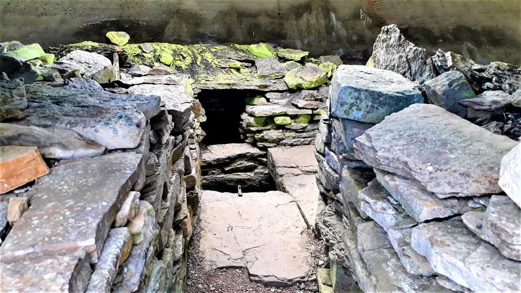
Black Hammer Chambered Cairn, with an interior divided into seven compartments by pairs of upright stone slabs.
Knowe of Yarso “This 5000-year-old chambered cairn was excavated in the early 1930’s with the remains of at least 29 people discovered inside. 17 skulls were lined up side by side”
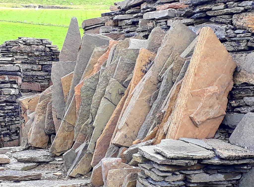
All of the tombs are enclosed in little bunkers for preservation. But that brings its own problems, algae, which is luminous green, thrives in the damp humid conditions under the sky lights that have been fitted.
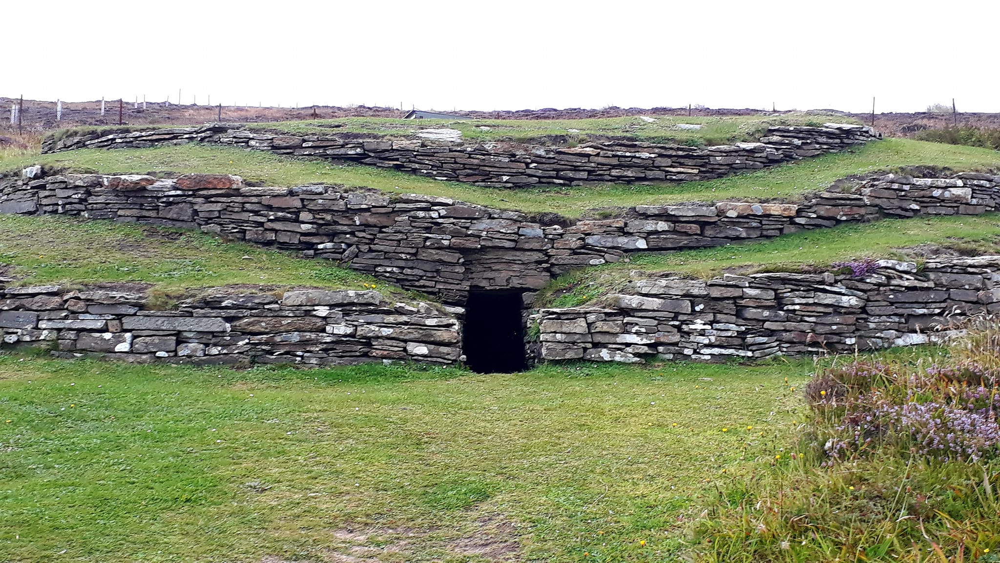
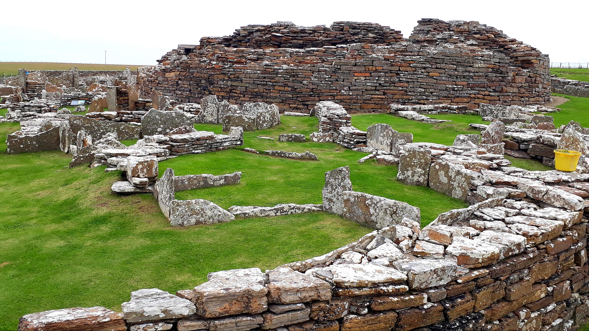
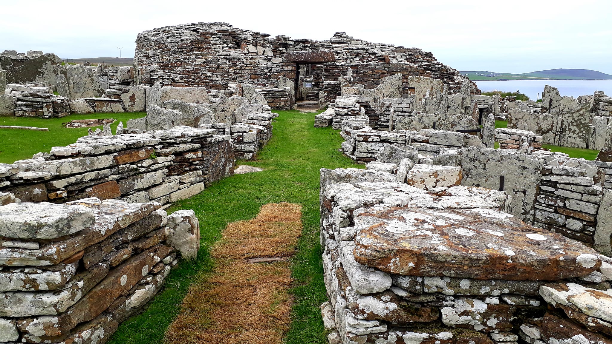
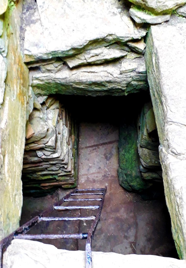
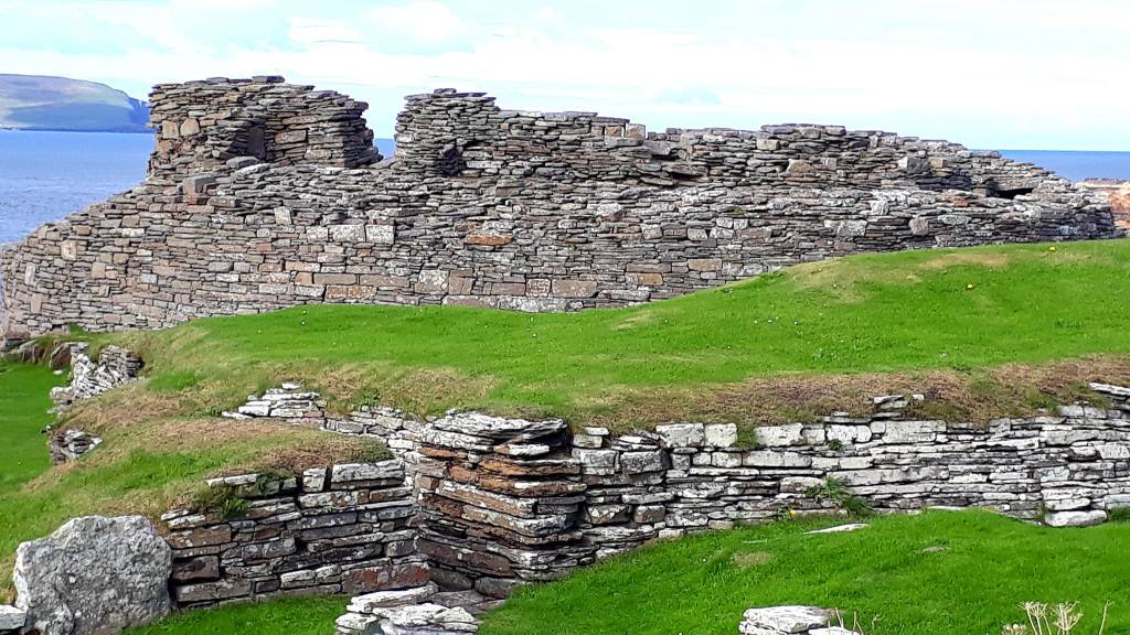
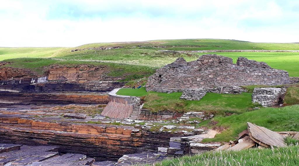
The best part of the day, of course, was the Midhowe site. Its the largest and most impressive of the 15 Neolithic chambered cairns on the island.
On the walk down, I noticed some structures along the coast to the left. So I wandered down there first. Shortly, I happened upon Brough Farm and old Viking settlement, The Wirk beside St Mary’s Church graveyard and nearby Skaill Farm.
“The present farm at Skaill dates to the 18-19th centuries and was part of the Rousay clearances during the mid-19th century; however the name Skaill suggests the site was home to a Norse hall or drinking hall, and was a high status site”.
A lovely find and it’s still being excavated, as the whole area is at risk from tidal erosion, damaging numerous sites.
I saved the best till last, Midhowe Tomb Chambered Cairn and Broch. What a place, at first the cairn looks like a vast pile of rubble in a hanger. But then you get great views from the scaffolding above… “The Great Ship of Death” … imagine…
Midhowe Broch is perfectly situated, as all of them seem to be. Smart people our ancestors. Right on the coast in a sheltered spot, great for mooring and launching boats for fishing and trade. Idyllic, I’d live here.
I chatted to a very nice young man, who worked there. He told me all about the important work they do. He was very passionate about the preservation of the islands monuments. Armed with a screwdriver, he gently teases out weeds, to stop them eroding the buildings.
It’s an endless task and a constant race against time to save these rapidly eroding ancient structures. I’m really impressed with Scotland Heritage, the level of preservation work that they undertake is outstanding, to keep these important treasures safe for future generations
Well what an adventure, my bucket list overfloweth, I don’t know where to put all that I’ve seen and learned, my brain needs additional hard drive. The place names on Orkney have a truly fascinating history, being mostly all Norse in origin. I would love to return and spend more time here and give this enigmatic place my ‘full’ time and attention.
I caught the 14.10 ferry back to Tingwell and the 16.45 ferry back to mainland Scotland, and I’m parked up behind two behemoth motor homes, somewhere in ‘Strathy’. I did inquire at a campsite, as I’m desperately overdue a shower. But she wanted £30 just for the night. She must be off her meds, no wonder the campsite was empty. Anyway, I’m away to my bed, I will figure out tomorrow’s destination in the morning
Today’s road trip tuuune – a farewell to beautiful Orkney – https://youtu.be/HFWKJ2FUiAQ
2nd September 2022
Day 6: Back on the mainland – Wick – John O Groats – Thurso (Orkney) ‘Strathy’ – Bettyhill – Tongue
Area: Caithness and Sutherland
After leaving the ferry last night, I continued along the North section of the NC500. Tip – don’t drive after 6 pm heading West. The sun sits very low, and I couldn’t see a thing.
I passed into Sutherland, on route, over heather moorlands and dune systems. My guide describes this area as “vast and empty, the landscape between Thurso and Tongue has considerable drama. It’s bleak moorland, inter-cut with sandy sea lochs, with few inhabitants. The real attraction of the landscape as you travel west, the rich farmland is replaced by stark heath-land, with the sharp profiles of Ben Hope (3041ft) and Ben Loyal (2507ft) emerging like twin sentinels from the blanket bog of the Flow Country”
Well that just about sums it up…
Courtesy of park4night, what would I do without that app; I found a sleeping spot at the entrance to Strathy Point. I tucked the baby beast beside two huge motor homes for protection. I felt like a baby elephant with its herd…
I woke to another gloriously sunny day, and planned the day’s itinerary. After thoroughly googling most of the suggested stops, such as the Strathnaver Trail, a heritage walk through ancient sites, mostly very ruined. I decided to blaze straight through. Having been spoiled the last few days, a pile of rocks, simply won’t do, but I’m sure the walk would have been lovely
I headed straight for Tongue, which was my end stage, before I diverted to Orkney, and stopped at Weavers Cafe on the outskirts of the village . A lovely picturesque spot for morning coffee overlooking the Kyle of Tongue and Castle Varrich
Today the guide warns again of ‘single’ roads, they are not that narrow and there are plenty of passing places. Whoever gets to one first gives way – I passed a huge lorry at one point, but the roads are pretty quiet
Driving is slow, due to the winding roads, but I did get up to 60 mph on long straight sections. But it’s like sailing a barge in a rough sea, due to all the undulations. Also the magnificent vistas are very distracting, stopping frequently to go wowwww, cows and sheep meander about, and some of the road surfaces will shake the fillings out of your teeth
The route passes through the Forsinard Flows. An important nature reserve, making up almost 5% of the world’s blanket bog. It’s a vast area of rolling peat and wetland, of Caithness and Sutherland, in the heart of the Flow Country.
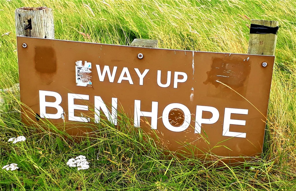
I took a rather long and slow diversion off the A838 at Hope, 8.36 miles on an unclassified road, to Bag Ben Hope, (3041ft) the most northerly of Scotland’s Munros. A designated SSSI, Ben Hope is a major site for alpine lichens with 34 ‘rare’ species recorded.
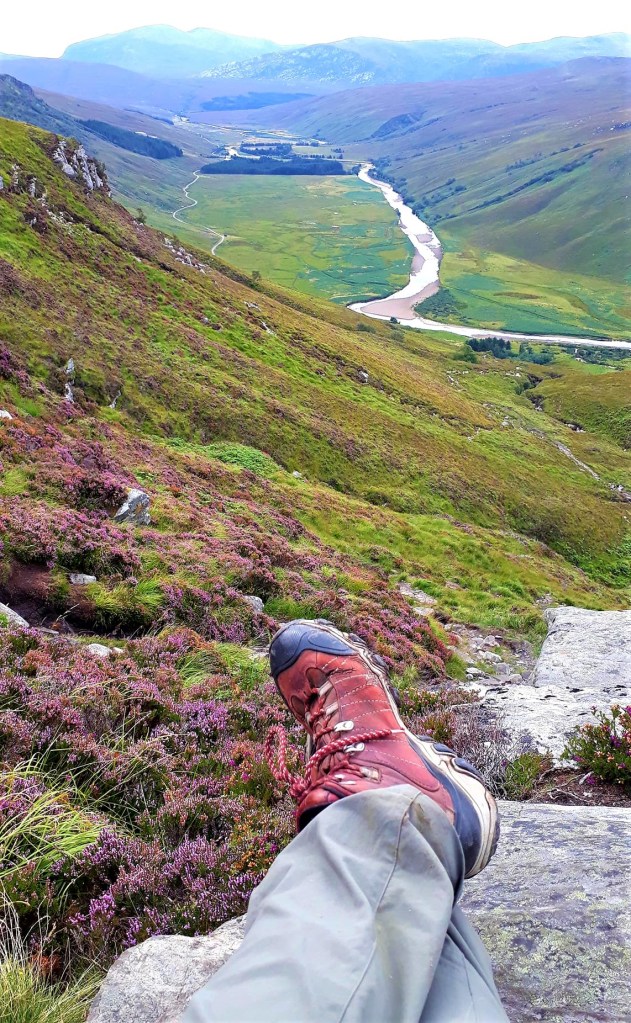
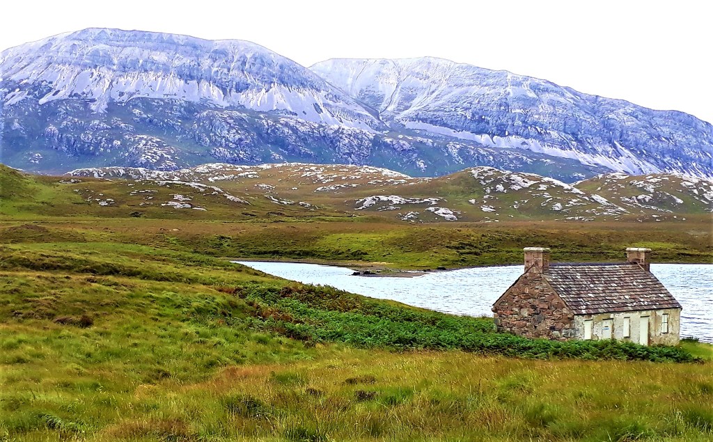
The approach is from a car park off the road (Strathmore) by a sheep shed, on the west side of Loch Hope. My guide book estimated a round trip of 4 hrs. I was back at the van, in just under 4 hrs, and that included a shower in a waterfall which was lush
I didn’t set off until 12 pm, a bit late in the day for my liking, but the weather looked good, despite the lively wind. It’s a deceptive mountain, it looks fairly small from the road, but there are lots of blind summits. Just when you think you have reached the top, up it goes again.
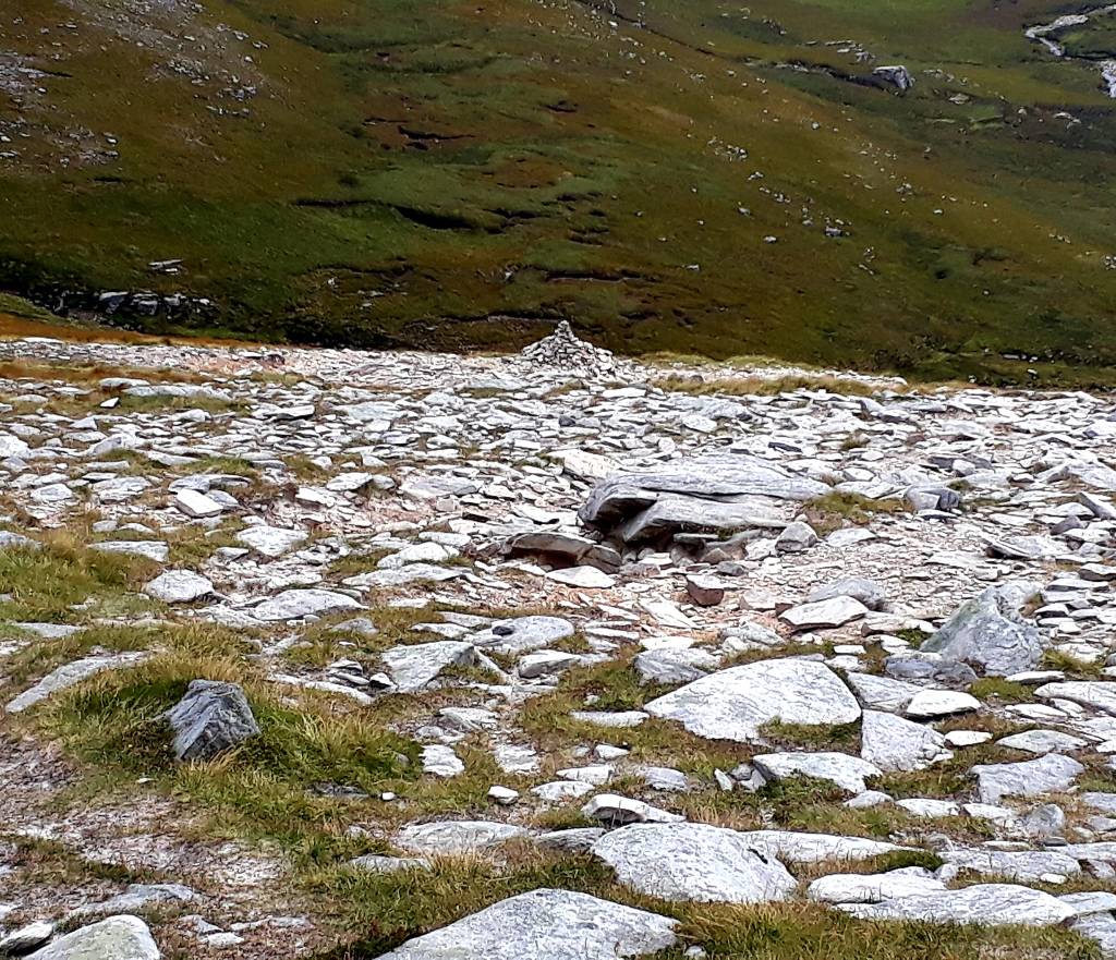
It ranges from steep climbs, to climbs, to very steep climbs, passes pools and waterfalls and cairns that guide the route to the summit. Everywhere the ground glistened, tiny particles of quartzite, I think, that sparkled like glitter. The wind, watering eyes and snot, all added to the drama of finding my way up. Also never believe hikers on the way down, that say “it levels out after this bit” or classic “you are nearly there” … they all lie


I was up at the summit and trig in 2 hrs, had a quick snack, and descended sharpish. Some brooding clouds were forming, that I didn’t like the look of. I hadn’t realised the steepness of the ascent, other than my frequent pauses. I blamed my poor fitness, but actually, it was so steep in places on the way down, I had to lean right back, dig in my heels and hope for the best.

It was easier to see the loose shale on the way down, so I diverted around that. But it was a quad burning experience and halfway down my thighs were shaking with fatigue. I almost wished I was going back up, it was actually easier on the thighs to nimbly trot down the mountain
With the car park in sight, I stopped at one of the waterfalls of Allt a’Mhuiseil. I was so very hot, sweaty and dirty, that +I stripped off and had the most wonderful bath and shower. I’ve always wanted to do that. I don’t know what came over me, I used to hate cold water, I’m going proper feral
I was back down just before 4 pm and headed for Durness, via what turned out to be a gigantic detour. The unclassified road I came in on is described as “one of the most challenging you’ll find in Scotland that still deserves to be called a “road”. Narrow, with infrequent passing places and a very poor surface, this is a road on which long stretches are marked by a strip of vegetation growing in the centre, between the wheel tracks”… very accurate description…
All the cars I had seen were coming from the other direction at a fair speed. So assuming that it led to civilisation, I went that way, in an attempt to avoid going back along that dreaded ‘road’. This route passed Dun Dornaigil Broch to the A836 at Altnaharra 24 miles.
Instead of turning left which would have taken me back to Tongue and then Durness (67 miles) I turned right toward Lairg, then right again back onto the A838, a very circuitous route along Loch Shin and Loch More to Durness, a mightly 93 miles, 2 hr 45 min detour…
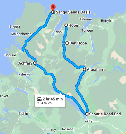
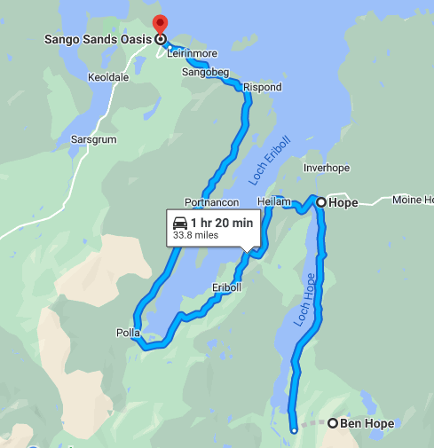
If I had gone back the way I’d come (34 miles) it would have taken an 1 hr 20 mins… more wasted diesel. But, I got to drive through the Corbets, within the Wild Land Area (WLA) with amazing views of some very dramatic pink and white quartzite mountains (The Geo Park)
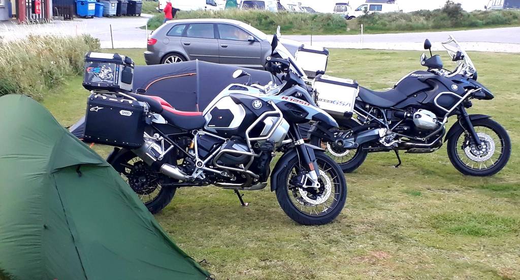
I finally reached Durness 6.30 pm and found the Sango Sands Oasis Campsite, on the headland. It was blowing a hooley, but I was glad of a hot shower and the chance to do my laundry. The beast and I now smelled lovely
My neighbors were a pair of bikers, they reminded me of Charlie and Ewan, road tripping on big bikes with expertly packed luggage. They were funny, pleasant and chatty and gave me change for the washing machine. They disappeared off to the pub and I cooked a hearty van meal
Today’s Road Trip Tuuune – https://youtu.be/sUFCkM-tNUQ
3rd September 2022
Day 7: The North West – Tongue – ‘Durness’ – Scourie – Skiage Bridge – Lochinver (89 miles)
Area: Sutherland
A blustery and bumpy night was had by all, but this is the North West, so livelier weather is to be expected. I took advantage of the wonderful showers again, found some Lynx in there, and I smelled wonderfully manly all day
Due to my ‘little driving error’ yesterday, I had to backtrack a bit. But the scenery was epic so I didn’t mind seeing that again. My new biker buddies packed up their tents and said farewell.
And just before I left, a pair of Ravens appeared overheard and honked loudly. Two of Odin’s messengers… I pondered if this was a good omen…
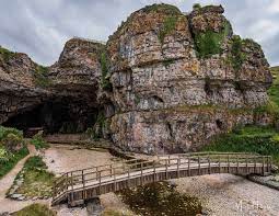
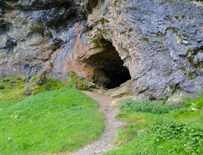
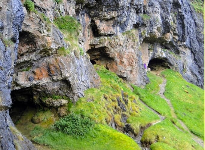
The day began well with a visit to Smoo caves, I recommend popping down there. The guides are experienced cavers and a pair of knowledgeable comedians. The fee of £10 pays for their ongoing digs, so do support them.
I got chatting to a couple of Scottish ladies from Sterling, who were very excited about the tour. The adventure starts in the cathedral sized entrance, on the beach, where you will be entertained by a Robin and her babies. Then the guides issue hard hats and take you into the caves. The 20 min guide is part inflatable boat and also walking through tunnels.
You may get to see the waterfall, it appears on a whim and can flood the chamber in minutes, it was not active today. But the rare Scottish Piranhas (brown trout) were, also saw tiny eels and bats are active at night. There are interesting Pamukkale type formations inside, and Fraser will tell you all about the formation of the cave… a brilliant trip.
Onward down the NC 500, but first some fuel. Quite often in remote villages there are self-service, 24 hr card only petrol stations, just two pumps. Sadly, there was no diesel so I headed out again. Just as I was pulling out, a car on the other side of the road reversed out into the road.
Clearly they had not seen me, and they came out at such a speed, I couldn’t get out of the way. All I could do was swerve to minimise the impact, lean on my horn, and wait for the crunch. Odin’s message… was clearly a warning…
Hearing my horn, the driver braked, but too late. I felt the beast lift with the impact and there was nasty crunch. We all got out to inspect the damage… and it was those two ladies from Smoo cave…
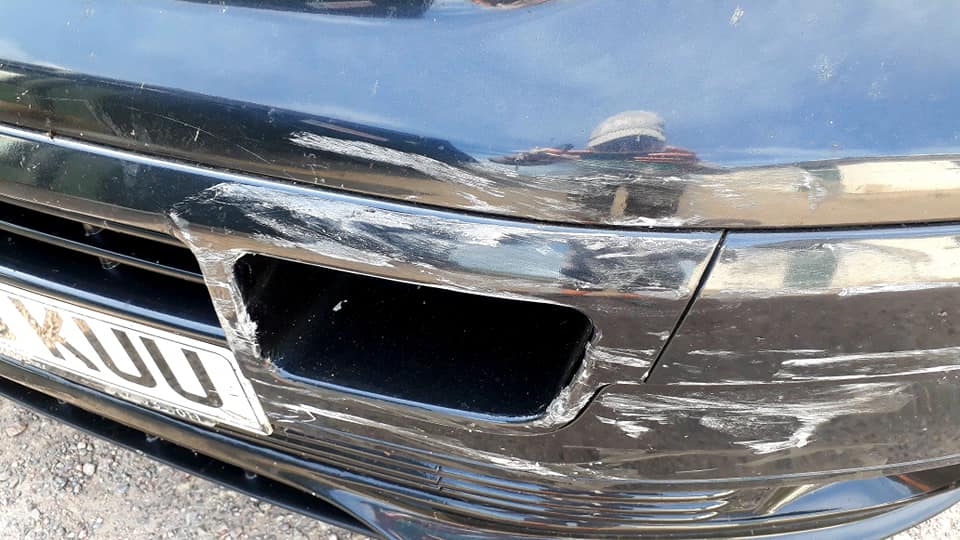
The first thing she says is “he will kill me” presumably meaning her husband, then “my nerves are shredded”. I’m thinking I will kill you; you just reversed into my van. The beast escaped with some nasty scrapes, but the wing on her car was hanging off. Details were calmly exchanged, onlookers made themselves scarce, and we all went about our day.
I decided to miss out Cape Wrath; you can only reach it by ferry or tour bus, or its an 11 mile hike, which would take all day. As the weather was rather blustery the ferries were unlikely to be running.
I stopped at cocoa mountain just up the road for a cup of the “best hot chocolate” and a pastry, to soothe my ruffled zen. Basically a cup of molten chocolate… I still had some left to make mochas with. Feeling a little calmer, I continued through the mountain ranges, they were in an altogether different mood to yesterday that seemed to mirror my own – dark and brooding.
Today’s route takes you through the dramatic and elemental Assynt and Coigach with a string of summits to bag. Not today in this wind, I was glad I bagged Ben Hope yesterday.
The route now transitions into Wester Ross and the Northwest Highlands Geopark. Assynt has some of the oldest rock formations in the world. You can see 3 main types if rock, Lewisian Gneiss (3000 million years old), Black Amphibolite, and the more noticeable and beautiful Pink Granite, that appears to glow.
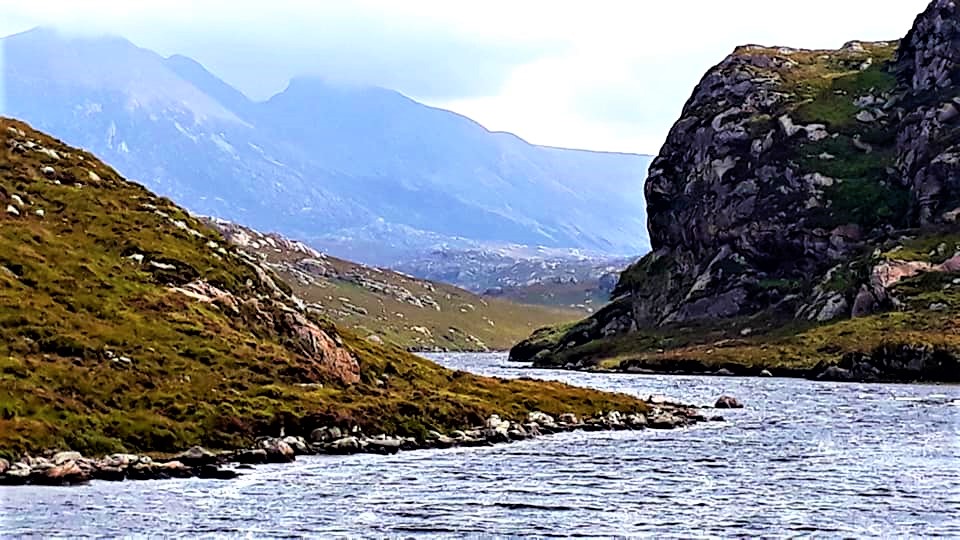
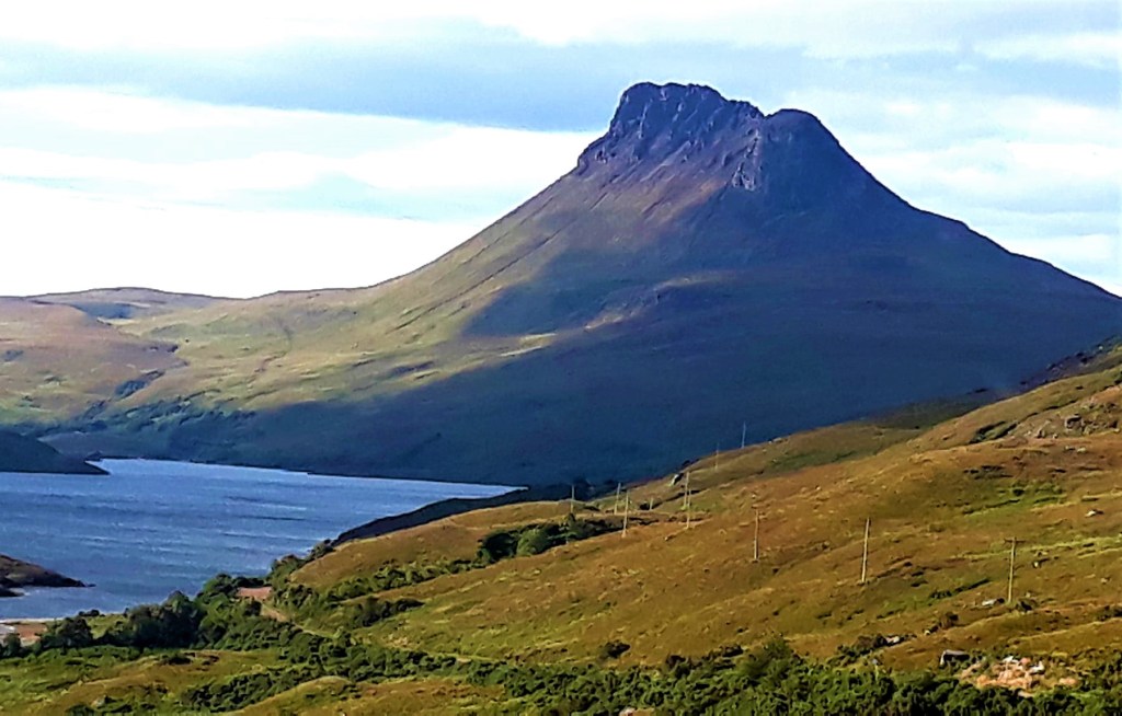
Assynt, in Old Norse is meaning ‘a rocky ridge’. You can get a fantastic view of them from Kylesku Bridge, most notably: Suilven, Stac Pollaidh, Canisp, Cul Baeg, Quinag, Creag Liath and Ben More Assynt


Another reason to stop here is the food van which serves venison, highland beef burgers and lobster. Today’s journey is more for passengers, if ever there was a place with too much beauty this would be it. For drivers the only option to take it all in is to stop… a lot … lest you crash from being immersed in the landscape. Towering mountains, purple heather, small lochins and white sandy beaches.
Today you have the choice to divert down the B869 The Drumbeg Road, which is also called The Wee Mad Road of Sutherland. It’s 22 miles long, running between Unapool and Lochinver and takes about 1 – 1.5 hrs. The route is described a picturesque with stunning views of lochs, mountains and sea.
I’m not sure I would describe it as stunning, partly because I didn’t dare take my eyes of the road, and a lot of it was tree lined. This road really is single track, but there are plenty of passing places. It was just wide enough for my beast, with steep hills, unexpected switchbacks and blind summits.
If you are a nervous driver, I wouldn’t recommend it. The road has steep sections, hitting a 25% of maximum gradient and reaches 436ft above sea level. It’s not suitable for large vehicles, but that didn’t stop two motor homes that passed me.
I enjoyed it, I wouldn’t go for the views, but if you fancy testing your rally skills, go for it. Having said that the Bealach na Bà, which I’ve yet to drive, is meant to be harder.
My day closed with a detour to Stoer Head Light House, where I walked 20 mins across the cliffs to the Old Man of Stoer Sea stack.
I sat in a sheltered and very warm spot, lay in the grass and watched the Fulmars gliding around the cliffs and Gannets diving for fish. I had seen a lot of dead Gannets washed up on beaches and I had this fanciful idea of them misjudging their dives and dying of concussion, but sadly, it’s likely bird flu.
As I walked back along the cliffs, I could hear this mournful sound, a bit like whale song. It was seals calling to one another from the rocks below. No wonder sailors were lewered to their deaths, by these strange and haunting sirens of the sea.
Sadly no sightings of wales or dolphins, which are reported all along this coast. Nor have I seen the Northern lights which are frequently seen from Durness.
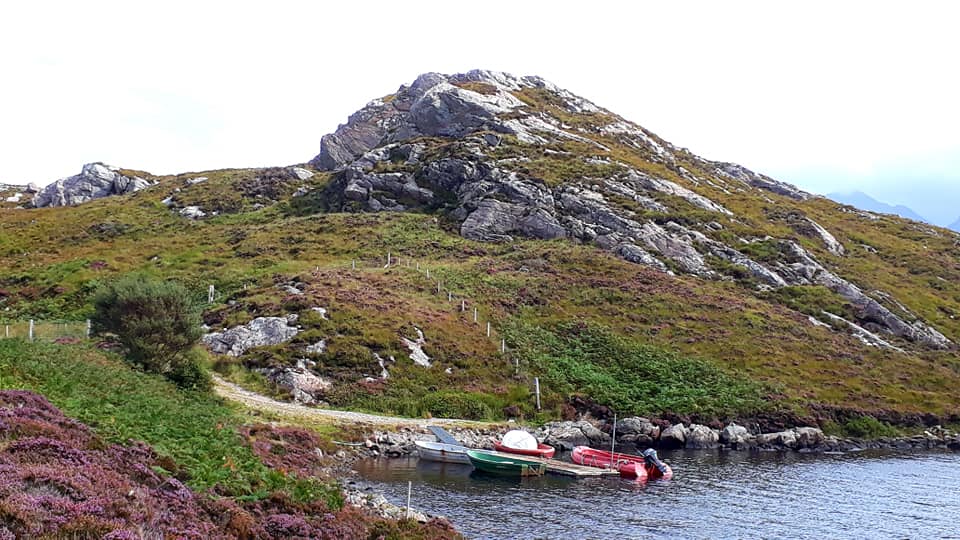
I drove as far as Clachtoll; parking spots are few and far between here, due to the rugged coastal stretches. The campsite was full, but I happened upon a nice man who was letting campervans park on his bit of land (£15)
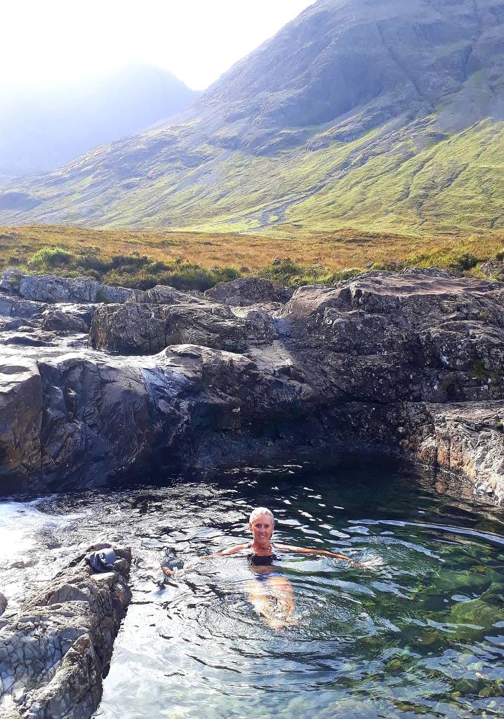
Its only 20 mins from Lochinver, there’s no signal here. But its right on Clachtoll beach, turquoise waters and white sand, so I wasted no time finishing my day with a most invigorating swim then watched the sunset.

The owner disappeared before taking my fee; let’s hope he returns before I leave in the morning.
Today’s road trip tuuune – https://youtu.be/cl3B_FTDKD0
4th September 2022
Day 8: Lochinver – Inchnadamph – Elphin – Ullapool (40 ish miles with Achiltibuie diversion)
Area: Sutherland and Westeross aka Ross-shire and Ross Cromarty
I slept like the dead from 9.30 pm last night, it had been quite a day. But I was aware of a storm blowing up in the night, strong gusts and a bit of rain. It was still very windy this morning, and I was about to experience the full fury of the mountains, strong winds and lashing rain
But first, I had to find my host and pay him for my stay. I found him at his bungalow, wandering about his yard in his PJ’s with a cuppa in his hand. He thought I had paid, bless him… We chatted briefly and I paid my dues, then headed off to Lochinver, it was hellish getting back up his drive, a steep dirt track full of pot holes
My guide describes Lochinver as one of the busier fishing harbours in Scotland, and an established reputation for food. Sounds fab, So I thought I’d stop there for breakfast…
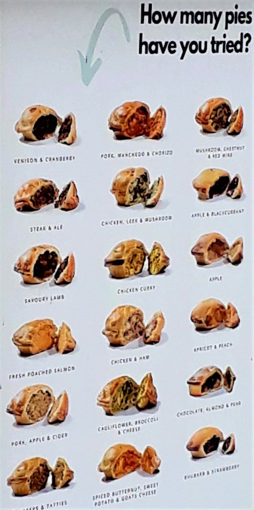
I would adjust your expectations, unless you are staying there or have a yearning for one or two of their famous pies, I wouldn’t divert off the A837. It’s one small high-street, ending at an industrial harbour, with nothing open on a Sunday, except the small spar shop.
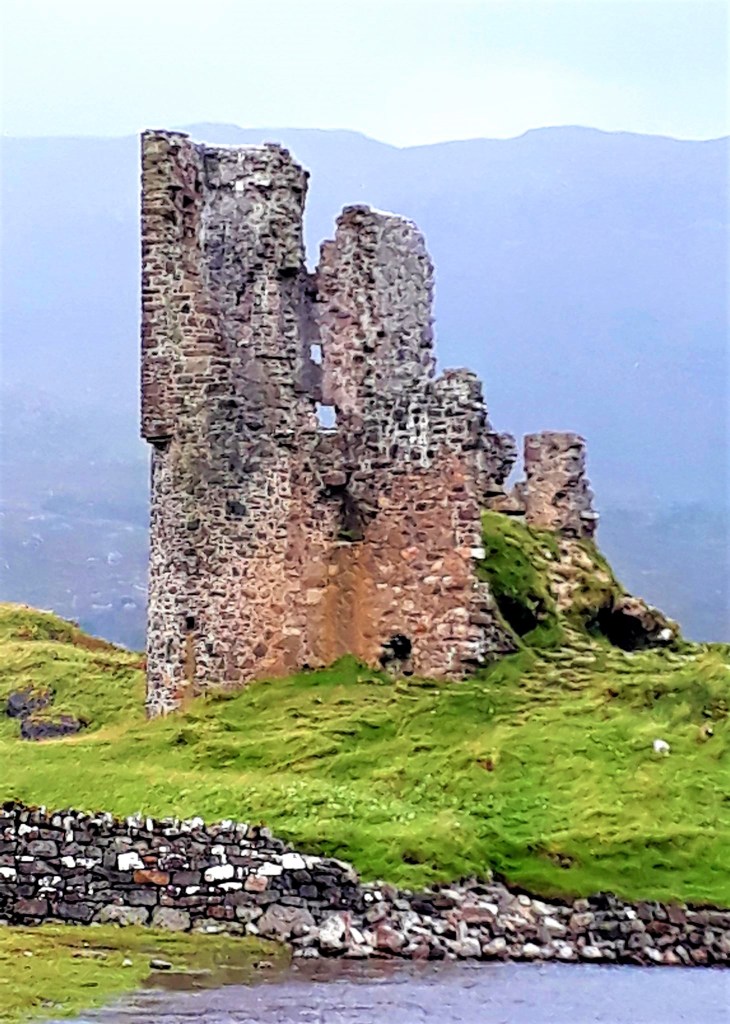
So I continued onto the iconic Ardvreck Castle, and ruins of Calda House. They didn’t disappoint even in the now strong winds and rain. The castle dates back to about 1490 when the lands were owned by the McLeod’s of Assynt. It has an interesting and tumultuous history. It’s a great place to sit and stare.
The journey, like yesterday, was all too beautiful. I passed right through the Assynt range, dark rolling clouds and the wind whipping up waves on the lochs and lochens. There were lots of local Sunday “rally’ drivers, speeding along this stretch of road, so take care.
Next stop, the Bone Caves at Inchnadamph. It’s quite a walk to reach them, worse and stupid in such bad weather – which was not too bad at the bottom…
Donned head to toe in waterproofs, I hit the trail. A few minutes in, and a pair of ravens appeared above, gave a sharp honk, then whirled away out of sight. Given the previous day’s near-disasters, I felt an unwelcome surge of apprehension. Was this a bad sign? I couldn’t help but wonder, and so I took extra care, just to be sure.
There were no trail signs to the caves, but a well-defined path, passed pretty waterfalls and higher up a huge dried up river bed. The path is pretty slippery when wet and I seemed to walk for ages. I began to think I had passed the caves somehow as there was no-one else about, and I was a bit worried.
Soon I came across a sign, warning of falling rocks, and I could see a steep climb up to a ridge, that looked familiar to a picture I had seen.

I carefully made my way up the slippery rocky slope, and found myself on a precipitous ledge, in strong gusting winds and lashing rain. I had no business being up here in this weather, let alone by myself. I remembered my mountain training, duck right down and lean into the cliff.
This strategy got me to the safety of the caves… and inside, sat there like a sage, was a young man, from Punjab… totally random. It’s odd, how at every summit, there is always a guy who will take pictures for you…
We chatted for a while, and it appears I took a rather circuitous route up. There was an earlier turning across the ‘dry’ river. But it doesn’t really matter; both routes were equally lethal in this weather. We exchanged photo shots and pondered how the river and falls, lower down, seemed to come from nowhere. As the river above was dry, we deduced the source must be fed by a cave or natural Spring.

I explored the caves and admired the views, then went back down the other route and my new Punjab friend went back down my route. It took me 20-30 mins to hike up and about the same back.
We met at the bottom and chatted over a hot chocolate. There is a lovely food stall there that serves hot drinks, panini and cakes. He did tell me his name, but I didn’t understand what he said… he told me he was a magistrate, age 29, very impressive, and had left his job in difficult circumstances. He was now travelling Scotland and then Europe before heading back to Punjab…
Such a nice fellow, we said our goodbyes, and I went for yet another swim in a waterfall pool. Whim Hoff has got nothing on me… it was bloody cold though.
Next I travelled onto Elphin, there is an activity centre there with a Tea room, so I stopped for lunch before heading for Knochan Crags. The weather cleared about 3 pm, strong winds still, but the rain had stopped and the sun was breaking through.
Now passing into Ross and Cromarty, the Knochan Crag National Nature Reserve, in the North West Highlands Geopark, has an educational walking trail. It tells the story about the rocks that set the scientific world ablaze in the 19th century – The Moine Thrust – which is most intriguing.
Lastly on route to Ullapool, I took a recommended diversion, just passed Drumrunie, to the Coigach Peninsula; the views of the mountains are amazing.
The road is a dead end at Achiltibuie, so unless you have accommodation out that way, I wouldn’t go that far. It takes about an hour, and the single track road with its bends and undulations, is tiring after a long day. I felt a bit sea sick by the end. I would turn around at the carpark at Stack Pollaidh.
I’m now parked roadside at Ardmair beach, just before Ullapool. There is a campsite, but a rather lively wedding is in full swing there… so no room at the Inn and no sleep tonight…
Today’s Road Trip Tuuune – https://youtu.be/DKL4X0PZz7M
5th September 2022
Day 9: Ullapool to Kinlochewe (Shieldaig)
Route: Ullapool – Aultbea – Gairloch – Kinlochewe (76 miles + 16 to just outside Shieldaig)
Area: Westeross aka Ross-shire and Ross Cromarty
Well, barely a wink of sleep was had last night… by the whole of this peninsula, I think. The wedding music didn’t stop till 5 am this morning. Who has a wedding party till 5 am?
I have a theory that everyone passed out on whiskey, and the music played on a loop. That’s what it sounded like, the same dum dum dum allllll night long. Even earplugs didn’t help. At least I was a little way down the road, I felt sorry for visitors at the campsite. I think I would have snuck over to the party tent and pulled the plug.
The night was also very blustery, even tucked between the mountains there was no shelter from the gales. I woke to lashing rain and I was glad to be in the warm belly of the beast and not camping.
With all that rain, I bet Smoo Cave had its waterfall…
So it’s my last two days on the 500, but, I want to make time to get over to Skye. So today’s bad weather will give me the opportunity to get extra miles under my belt with nothing to distract me. There is a suspension bridge on route today, but I didn’t think there was much chance of walking over that in the bad weather…
One Raven appeared this morning, and cawed softly as he passed overhead. They seem ever present now, watching over me, I took note to drive carefully in the poor conditions
But … just as I was about to hit the road, the wind dropped, the rain abated and the sun appeared. The weather was glorious all day… the Raven had bought good tidings …
I headed to Ullapool first, for some breakfast for me, and fuel for the beastie. Ullapool is the Northwest’s principle town, so it’s pretty busy, with lots of through traffic and only one tiny petrol station. It’s one of the last places to stock up with provisions and fuel before heading to more isolated areas.
I needed fuel before taking on Applecross Pass tomorrow. But people were being impatient and driving like Muppets into the petrol station, so I waited for the panic to die down to avoid another collision.
Meanwhile, I enjoyed a bacon butty and a stroll along the harbour. You can go Whale watching, but I missed the boat and I didn’t have time to wait for the next. All fueled up, the next stop was Corrieshalloch Gorge National Nature Reserve.
My route today followed larger more sensible roads. The sheep are in fields and unlike previous days, not hanging out in the middle of narrow roads, staring at you, chewing slowly, like a petulant teens. They move out of the way when they are ready… which is like… wheneverrr
Saw my first highland cattle today too, hoorah
The landscape has changed, its greener and more forested, with its own ecosystem, mist hovers above the canopy in places. There are signs for Red Squirrel everywhere, but I’m yet to see one of these illusive rascals.
As wonderful as the mountains have been, their rugged and dramatic majesty, is stark contrast to the gentle green of woodland scapes. Huge Scots pine, I assume, with their massive trunks among other natives, such as oak, mountain ash, and alder
I spent a good hour at the gorge, walking the suspension bridge and the trails, I highly recommend. I’ve missed ‘green’ it’s nice to back among trees. The sounds, colours and dappled light, as the wind blows through the branches and leaves… forest bathing, this is peace
I stopped for cakey tea somewhere around Aultbea, overlooking Loch Ewe. In fact today has been one stunning view after another. Westeross has got everything, mountain views, and lochs, woodland, coastal scenery and beautiful beaches.
When I return to Scotland, it would definitely be the West Coast, but I would spend more time in just a few areas. I passed so many places today that I just don’t have words to describe, where I could have happily whiled away the hours – beautiful doesn’t quite nail it
The best way to travel this stretch, is if you are not bound by time, and can just stop and move on as the mood takes you. I’ve been tearing myself away from stunning vistas all day.
One such place was Gailioch; it’s in two locations really. The first side is a high street, with cafes, shops etc., lovely sea front where I enjoyed a swim and a snorkel. It’s really deep right off the rocks and the water is crystal turquoise.
About a mile down the road is the harbour, gorgeous little place, with loads of places to sit along the waterfront, and gaze at the sea and the mountain landscape before you… truly awful, you will hate it…

Here, I missed another whale spotting trip… bugger… timing
My journey was going to end in Kinlochewe today, but I wanted to get a bit further so that tomorrow is less arduous… more about that in a moment.
The journey to my parking spot, just before Shieldaig, was nothing short of spectacular… so many places to just stop and admire the views, lochs and their little islands, sandy beaches and lastly through the Beinn Eighe National Nature Reserve… all too beautiful for words
Anyway, so I didn’t see any Red Squirrel, I didn’t see any Whales or Dolphins, and I didn’t see Mr Eagley… but I did see a very majestic Stag in a car park…


So much to take in, I don’t want to forget any of this trip. All to soon we go back to our mundane lives, and the memories fade and lose their sharpness, I want to permanently imprint this in my mind.
I found the perfect pitch for the night on the edge of Loch Shieldaig and after a refreshing swim, I cooked a hearty dinner and watched the sun set
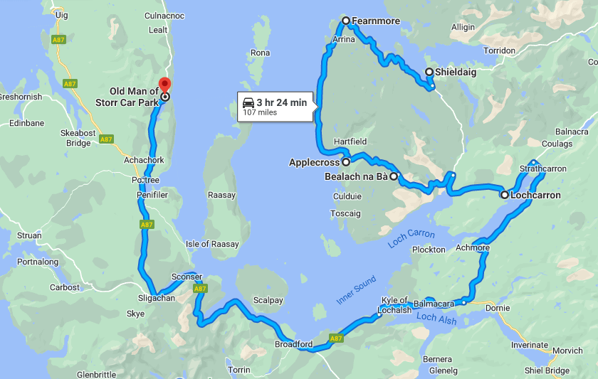
So, tomorrow I head for Applecross over the Bealach na Bà. If you haven’t heard of this before, read on… I am a bit nervous… if you don’t hear from me again, I’ve seriously had a blast
Today’s mega road trip tuuune https://youtu.be/XmU4Xyl00hY
6th September 2022
Day 10: Kinlochewe (Shieldaig) to Skye
Route: Sheildaig – Applecross – Lochcarron – Skye – Old Man of Storr (108 miles – a long way) Area: Westeross
Odin’s Ravens (or just The Wind and the Birds?)
It was a peaceful night at my little camp on the loch, shared with three other vans, a tent, and a motorhome. Some had campfires; I, however, was driven inside by midges.
The wind picked up significantly during the night, making me wonder if I should even attempt Bealach na Bà. If it was as bad as they say, I certainly didn’t want to be caught up there in bad weather. I woke early, apprehensive, as it was still quite gusty and rain was forecast for midday.
So, I figured if I was going to go, I’d better go over the pass while the weather was still good. I lashed everything down in the van, anticipating a bumpy ride ahead. I said a silent prayer to the gods – none in particular, any and all, just in case… And then, a raven appeared. Then a pair… then three, four, five, and six.
They created quite a ruckus, cawing loudly, whirling about in the strong winds right overhead. What could this mean? One even made several short caws that sounded uncannily like laughter. Were the gods laughing at me – at my stupidity or my fear?
Who can know, but as I set off, so did they, following my direction. Whirling away out of sight, then reappearing at regular intervals, as if they were guiding the way.
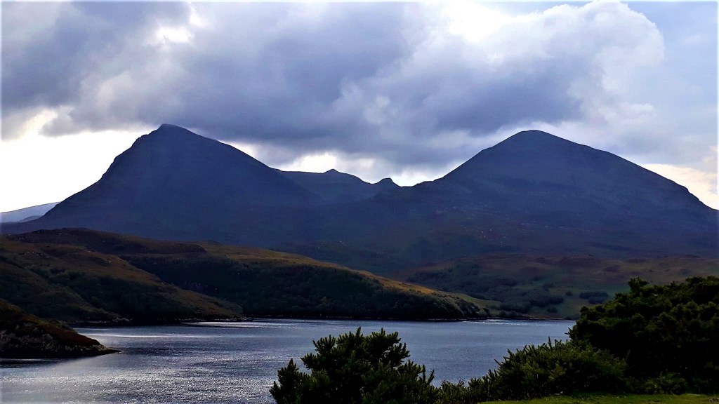
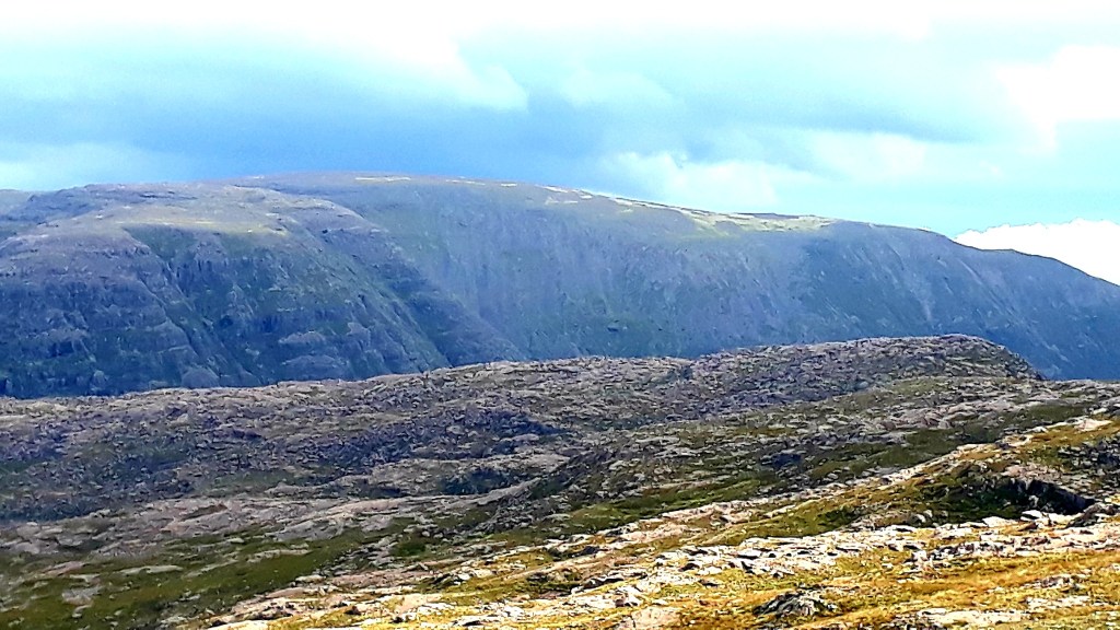
I took the coastal route to Applecross, around the peninsular. A slow single track road that twists and turns through pretty landscapes. Along the Torridon Sea Loch and the Liathach (3461ft) and Beinn Eighe (3314ft). 750 million yr. old white quartzite, that sit with the 15 thousand acres of the massif, under the protection of The National Trust for Scotland.
There were some steep climbs, preparation for what was about to come, and there were great views of Skye, Isle of Raasay and Rona.
Applecross itself is a quiet, pretty place, with red sand and rocky beaches. It’s believed to be one of the earlier places to be settled in Scotland. With its sheltered bay, it’s now a haven for kayaking, boating, fishing and hiking.
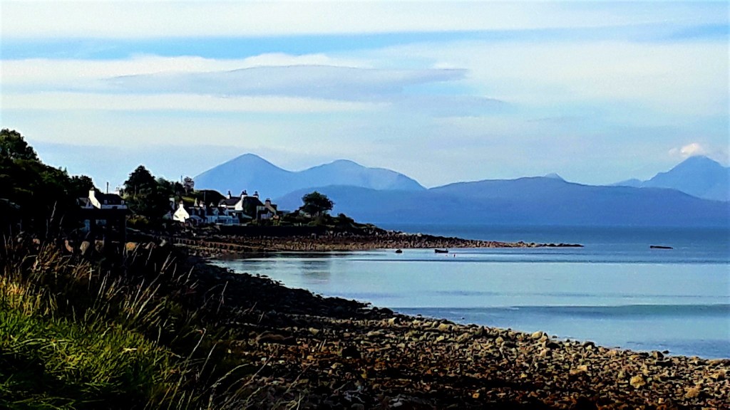

There’s a nice pub, with a coffee bar outside serving bacon butties, so I stopped for breakfast. The bacon was delicious; but the coffee was the colour of treacle, but I would need supreme focus shortly, so down the hatch…
There was much banter going on about a group of bikers that just left – The ‘Blue Knights Chapter‘. It looked like their mum had made their patches for them, light blue and a bit Monty Python. One of the guy’s googled them, they were German Police…
The bay looked tranquil and the sun shone, it would have been perfect for the paddle board (Fat Betty). But there was nowhere convenient to launch, without breaking an ankle across rocks. Plus I really needed to get moving
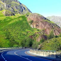
A sharp turn right, from the village, takes you toward Bealach na Bà. It all looks very tame for the first few miles. A nice road through moorland, reminiscent of Dartmoor, dodging the imperious sheep… great views as I approached the pass.
Then it starts to get interesting … the road hits a steep incline, with a tight switch back toward the top. The beast nimbly negotiated her way up. The only obstacle, a big camper coming down, but he waited.
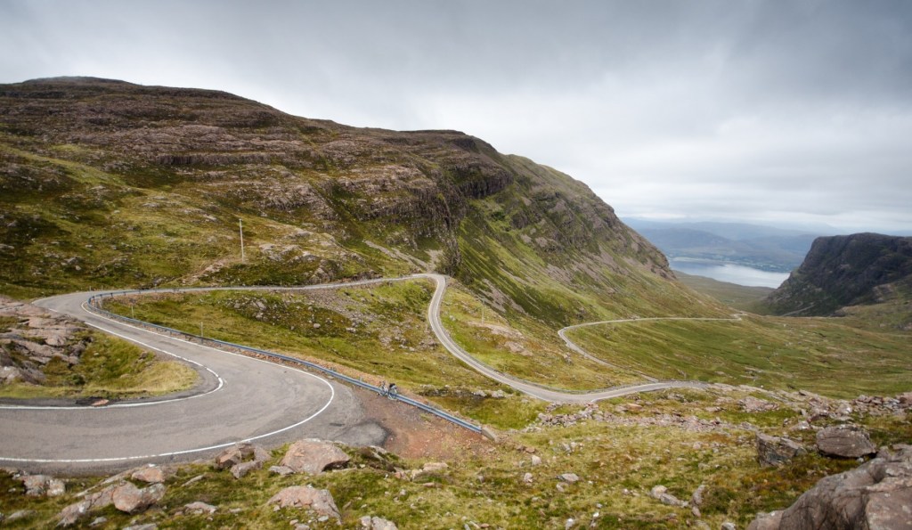
There is a small parking space at the top, where you can stop and take in the views of the massif.

Then the run back down the other side was fun and games, as I was stuck behind a motor home, along with everyone else on the pass. I admired the drivers ‘steel’ and driving skill around the hairpin beds… but he was blocking the road for everyone coming up and trying to get down
The road in places was just wide enough for the beast’s wheel base. In places there were sheer drops, with some barriers that might stop you going over edge? Lots of ditches, where it would be game over, you would turn your vehicle over if you slipped in.
So immense concentration is required, you will be fine if you take your time, and no one panics… I can imagine the carnage when it’s busy up there.
Our hapless motor home driver got us well and truly wedged as he tried to pass a VW and a lorry in a tight spot, rocks one side, a ditch and water the other. He squeezed through with millimetres to spare, and caused havoc on the chicane on the way down…
This is why, they recommend NOT taking motorhomes or long vehicles over the pass… according to locals, all summer long they have to send rescue teams to get these idiots down again. I drove the pass East to West, which is recommended, as the worst of the chicane are the Locharron side, and its better going down them.
Once down, I stopped in Lochcarron for a while, to take a break, quite the white knuckle ride, I’m sure a few people needed to change their underwear afterwards. My legs were like jelly, but that could have been the earlier coffee.
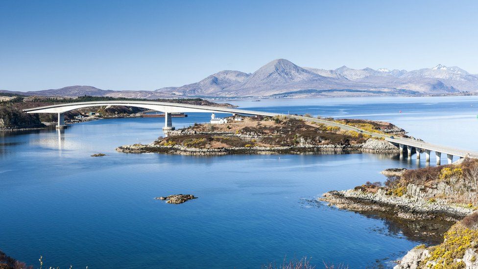
From here the route passes the twin sea lochs, of Loch Kishorn, which is so deep it was once used as an oil-rig construction site, and Loch Carron which I now followed, off the NC 500, to the Skye bridge.
I paused on route for views back along the loch, and to take a call from the insurance company of ‘Smoo Cave lady’. She had accepted liability for the bump, no quibble and the wee beastie will be fixed… great news
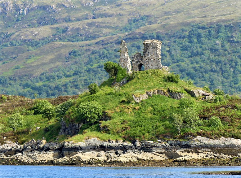
Onward over the bridge to Skye, which is pretty impressive, a late lunch at the Haarken Bar, Kyleakin. It has great views back over the Applecross peninsula and Caisteal Maol. Then an hour’s drive to The Old Man of Storr. Well worth the long drive after a long and tiring day.
The Ravens were there to greet me on my arrival, calling and whirling above, guiding me onward and upward to the summit. As a talking bird, the raven also represents prophecy and insight… they certainly spoke to me. And if disbelieving readers think the Ravens are a figment of my wistful imagination, check out my video…
It’s quite the climb to the top, but I’m putting in the hard work so you don’t have to. It’s an hour up to the best viewing spot, which was a small peak to the right. It’s quite an impressive and imposing stack, home of the Ravens who whirled and called above its peaks

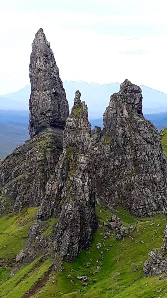
From the car park there is a loop you can walk, which I did, or you can take the path straight up to the right. I’m not sure if either route are easy or quicker than the other, but it’s pretty slippery on the way down
The Storr, meaning big or prominent, in Norse, is a large standing formation of rock that was once part of the Trotternish ridge, which is a 19 mile inland ridge that was created 11,500 yrs. ago

One of the things that struck me, was the extensive deforestation on the slopes. I only hope there were valid conservation reasons and not to provide a good view from the road for tourists…
I found a busy parking spot for the night further along the road. Skye is the busiest place I’ve been since leaving Inverness. Camper vans and motor homes had taken up far too much space, and no-one else could get in.
I spotted some room next to a German T5, but it was a tight squeeze. So I wrapped on his window and asked if he could move up a little. His response “ooh I don’t know, he (the van in front) has already rolled back toward us” then realising his weaselly excuse, he agreed to move “just a little”
I saw them sat outside later; getting savaged my midges… karma…
So tomorrow, I shall continue my tour of Skye
Today’s road trip tuuune – https://youtu.be/1u-niluB8HI
7th September 2022
Day 11 Skye: Route: Around the wee Island
I awoke to a pair of Ravens, sitting quietly on a fence, preening each other, they had no messages for me. I learned today (at the Staffin Dinosaur Museum) that Ravens are much maligned on the island for killing lambs. I will spare you the gory details. But there are so many here, that a cull is being proposed… Odin will not be pleased
I was too tired to fully appreciate today, all the wonder and excitement has finally caught up with me. Being a small Island, nothing is too far away, it just takes ages to get there on the god awful roads, I’m so done with them now, the bone shaking, twisty turny, arsehole roads…
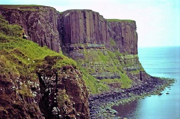
So today, I mainly, rocked and bumped and rattled and rolled slowly around Skye and just stopped when I saw something that caught my eye. First up, Kilt Rock and Mealt Falls, which are made up of basalt columns resting on a sandstone base, stands 90 meters high and is said to resemble a kilt. On clear days, you can see the Isle of Lewis and mainland Scotland from here

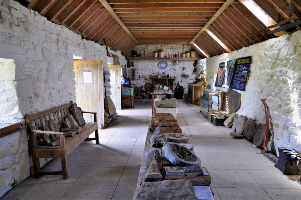
I little further down the road, I happened upon the tiny Staffin Dinosaur Museum, that boasts having Skye’s Internationally Acclaimed Collection of Dinosaur Fossils.
This is no bold boast, Skye, often dubbed the dinosaur isle, is the only place in Scotland from which dinosaurs have been found and has more than 10% of the world’s Middle Jurassic dinosaur species and more than 15% of the Middle Jurassic dinosaur sites.
It has a wonderful collection of specimens; all found on the island, at £4 you can’t go wrong, a lovely little find
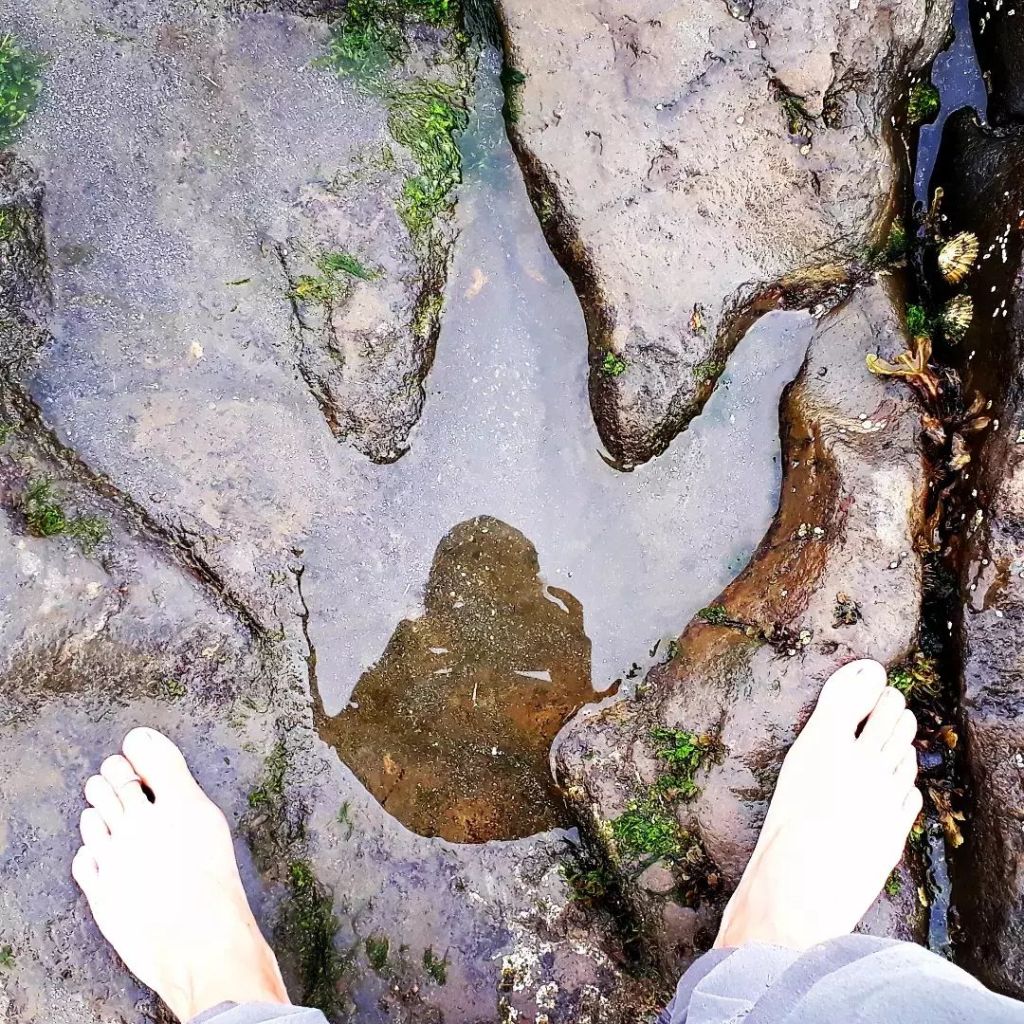
More excitement… I then stumbled across the Staffin famous dinosaur footprints at An Corran and walked in the footsteps of dinosaurs. Bloody brilliant, this holiday just keeps on giving. Scientists believe that the footprints were made by a predatory dinosaur similar to Megalosaurus.
Next stop along the coast is the ruined Duntulm Castle, believed to have been first fortified in the Iron Age, and the site continues to be associated with the name Dùn Dhaibhidh or “David’s Fort”. Later in life it was fortified by the Norse, and subsequently by their successors, the MacLeod’s of Skye
I didn’t learn until after I had left, that there are more dinosaur footprints beneath the castle on the beach… damn it
A had a quick look around Dunvegan Castle, not really my cup of tea, and I was seriously road fatigued at this point. If you are one of, or are interested in the Clan MacLeod, this might float your boat. It’s one of the oldest continually inhabited castles in Scotland and ancestral home to the Chiefs of Clan MacLeod for 800yrs. The gardens were nice, very autumnal, but no cafe
Lastly, the beast carried me across some shockingly pot holed roads to Neist Point Light House. I got here about 4 pm and here I shall stay until the morning, I’m done there is no way I’m tackling that road back today.
And if you think I’m exaggerating, read this
There’s even a Facebook page, ‘The Skye Pothole Appreciation Society’… no really …
And the Skye and Lochalsh Pothole Group … serious stuff this one
So finally a nice walk, to regain my Zen. It’s quite the walk down to the lighthouse and even more of a climb back up. But it’s worth it for the views of the nesting birds, and the islands. I also found a cheeky little spot for a refreshing swim, I’m feeling much restored.
There are tons of vans parked up here, people playing guitar, BBQs and beer; it’s a mecca to watch the sunset. So here I am sitting on the edge of the world, watching gannets fishing, waiting for sun to go down


Today’s bone shaking road trip tuuune – https://youtu.be/gj_hTbyYZz8
8th September 2022
Day 12: Skye back to Inverness
Route: Skye – Eilean Dolan – Loch Ness (approx. 150 miles)
Area: Skye – Inverness-shire
I woke to strong winds, blowing about the headland, and the van this morning. It sounds like winter, but it’s still warm, the sun was shining, and the sea was the bluest of blues
It’s been really warm for the whole of this trip. The only time I needed to wrap up a bit, was on Orkney. First order of the day was to get back off this headland without shredding my tyres. A farmer on quad bike, with his two collies, did a drive by… it’s time to go.
It’s a laborious 30 minute drive back onto the main A863. Back down the single lane, frequently pulling over for other vehicles, dodging the interminable potholes. The repairs, which are not flush with the road, just add to the whole painful experience. So spare a thought, if someone is driving slowly in front of you, they may not have your good suspension
It’s not all the fault of Skye’s road maintenance however, the earth here is still moving. The 8.5-kilometre area around the Quiraing is still geologically active and moves a few centimetres every year. This ‘landslide’ is the largest of its kind in the UK’s shape-shifting history. The nearby road has to be shored up annually as it opens up to crack and splinter.
They should hire quad bikes to get around this island, but it’s a place for hiking not driving. I headed for the ‘Fairy Pools’, this morning, by the time I got there 9.45 am, it was already rammed with excited tourists. I’m always dubious of anything that starts with the word fairy.
After having walked the falls… my impression… is that it would be lovely in the winter or spring, it’s been a very dry year and I’ll just leave it there. But, it was a lovely morning’s walk, and my last opportunity to wild swim in a Scottish pool. It was wonderfully refreshing. There were also impressive views out towards the Black Cuillins, the source of the River Brittle, which all made the £6 parking fee worth it.
Tip … if you want to avoid the parking fees there is a small free parking area before you get to the main tourist one.
After my refreshing swim and now having a spring in my step, I headed (4 miles) down to the ‘Award Winning’ Glenbrittle Campsite & Cafe, for an artisan coffee. It’s at the foot of the iconic Cuillen mountains and Loch Brittle beach. There is some limited parking and they weren’t serving ‘food’ till midday, but you can get coffee and cake and just enjoy the views.

The site is an ideal base camp for hill walking and I would definitely come back here for some proper hiking and wild swimming
Alas, it was time to start heading home; I was not sad to be leaving Skye, and its interminable roads. I much preferred Orkney. But this is prime hiking country and I would like to return to bag some of those amazing peaks someday. I’m a better hiker than a tourist, but this was a road trip, and you can’t have it all. So I said farewell to the Island of Ravens and drove back to the mainland.
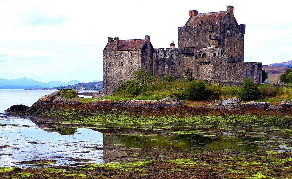
You can’t leave Scotland without a visit to the iconic and most photographed castle Eilean Donan. And what a beauty, sitting on a small tidal island on the junction of three Lochs – Loch Aish, Loch Long and Loch Duich
I snuck into their ‘very ample’ car park, with my previous ticket, don’t judge… then I sat on the shore, away from the crowds, and enjoyed some awesome clam chowder from the cafe.
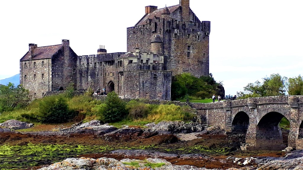
The castle has a long history; the Island itself has been occupied since 634 AD when Bishop Donan built a monastic cell there. The first castle was established in the 13th century to protect the area from Viking incursion. Its privately owned today and still lived in from time to time, it was most enchanting.
Time to bring my wonderful adventure on the NC 500 to a close, and as I left for Inverness, it started to rain… I’m known for my ability to charm the weather, I bring the sun and take it away when I leave… or I could just be lucky
Whatever the reason, by the time I reached Beauly, it was lashing it down. I got as far as Loch Ness to a roadside campsite in Drumnadrochit and will weather the storm here until the morning. No grand views, no grand sunsets, just haggis out of a can… my mood plummeted.
It is the end of the Scottish 500… but it’s not the end
Today’s road trip tuuune – https://youtu.be/ADP65wbBUpc
9th September 2022
Day 13: Reluctantly going home… (Outskirts Penrith 292 miles)
Last night the rain abated late evening and I was able to wander to the shower block, although I didn’t want to wash it all away, the adventures and the experiences, and return to ‘normal’
But to keep the post adventure blues at bay, I planned some more adventures on route home. As it happens, I was only 5 mins away from Urquhart Castle so I headed there 9 am to beat the crowds. Before exploring the castle, you have the opportunity to watch a short history of the castle in the auditorium
I recommend it, even just for the great reveal afterwards. A curtain opens at the end of the presentation, to reveal a huge curved window, that looks out over the Castle and Loch Ness, it’s quite spectacular.
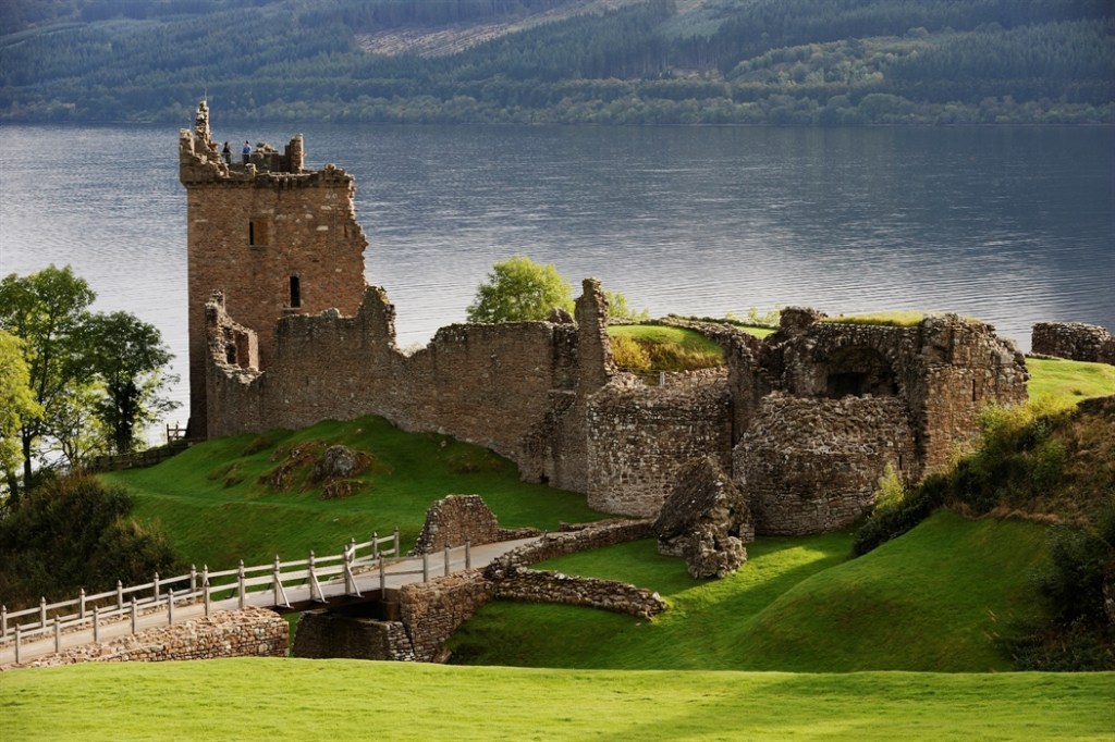
Urquhart Castle has a lively history and played a role in the Wars of Scottish Independence in the 14th century. It was subsequently held as a royal castle and was raided on several occasions by the MacDonald Earls of Ross
This latter piece of information has a fascinating history of its own… along with other clans, the MacDonald were part Irish, part Viking…
You can access the shore of Loch Ness from the castle, so I took a stroll. The weather has definitely taken an autumnal turn, and the Loch was wild and white capped. I tried to take every last breathe of Scottish air before leaving
Back on the open roads once more, it was pretty much smooth sailing out of Scotland. The beast purring along without the interruptions to momentum of previous days (Potholes)
Just before Fort William, google maps diverted me off the A82 onto the A86, A889 and A9 toward Perth. I was now passing into the Cairngorms, which was very different from Glencoe’s brooding and dramatic mountains. This region is much greener and forested with an altogether gentler rolling landscape.
I passed by Laggan Dam, where there are great views of Ben Nevis. Then I paused for a much needed break and lunch stop at the Laggan Wolftrax Centre, a perfect spot for mountain biking or hiking.
But alas no time for that, I had many many miles to go. My journey continued on the M80, M8, and M74 skirting nicely around Glasgow, what a relief. I arrived at a parking place somewhere outside Brampton (54°54’56.9″N 2°41’22.8″W), around dusk, road weary and hungry.
The spot had 5 stars on Park4Night, secluded with fantastic views over Talkin Tarn, the Eden Valley and across to Southwest Scotland… sounded fab… and it was initially. I had it all to myself, so I cooked dinner and settled down for the night
I was joined by a motor home shortly after dark, an older couple with 2 dogs. They parked the other side, opposite the exit, whilst I was tucked in the corner with the exit to my right… rookie error as it turned out
Our peaceful night was disturbed by a car full of ‘youths’ about 10 pm, playing loud music and chatting, right in the middle of the car park. As they had left their lights on and the engine running, I assumed the pesky rascals would sod off shortly.
But no, they were joined by another car of lads and then another, the atmosphere took a sudden darker turn. Loud music, loud voices, shining torches into my van. The dogs in the motor home were now alarmed and barking. The youths were barking back, drink and dope were involved
I realised that I was now hemmed in, and couldn’t escape, should I need to. The motor home could have driven straight out but thankfully they stayed put. Perhaps because they had seen me earlier that night, and unlike our rowdy invaders, knew I was a lone female and that it was a potentially vulnerable situation…
I thank them if that was the case, it’s the first time I have felt really scared on the road, well almost… there was this other time… but that is another story…
But… one of the advantages of a black van… you don’t know who is inside…
So in terms of ‘fight, flight or freeze’ – staying silent and not giving yourself away is by far the best strategy. Nothing unnerves others more, than the unknown…
Their full moon antics continued until gone midnight when they finally fucked off and we could all breathe again and get some sleep
10th September 2022
Day 14: The M6 Road to Hell – desperately trying to get home… (approx 200+ miles with lots of diversions)
The following day did not improve, I was now in Cumbria, with many miles still to go. The morning started well, I had planned some visits on route back to Cornwall.
Firstly, Penrith Castle, (sadly a shadow of its former self) surrounded by modern invasions, a train station, McDs, Supermarkets etc. No atmosphere to be found here …
I moved on, to Shap Abbey, a peaceful little site on farm land. Then onto Brougham Castle where I had a massive history nerdoff with the Heritage guy there ![]()
Brougham Castle is rather special, it’s away from the town, although you can still hear the M6. The castle is full of twists and turns and little passageways. The colour of the stone and the light/shadows are aesthetically pleasing. Plus it has an interesting history being near Hadrian’s Wall and all
Back on the road afterwards, it should have been a straightforward 3 hour drive to Shrewsbury, my destination for the night. But the Gods of travel had other plans… traffic was diverted off the M6, due to an accident/works?
It was absolute carnage, it didn’t matter what clever diversions I took; they all ended up in traffic queues. I was kicking myself, I always do this, hitting the M6 at this time of day, always ends in tears…
It took 3 hours just to get passed Lancashire and the other side of Preston, I nearly blew a gasket. Such a jolt back into the busy world of humans, all rushing to be somewhere… until the M6. Still at least I got off the M6; hundreds of poor bastards were stuck there not moving for hours
I stumbled across a campsite, around 6 pm, at Wem, near Shrewsbury – well it’s a small village really. My idea of hell, a karaoke bar one end and a family bar with music the other, fucking gnomes everywhere… seriously, mass gatherings of humans is so overrated. Well that was the shitiest night and day ever… bring back my peaceful highland spaces.
The only nice thing about this site is the loud rookery and the Guinness 4 pk from the shop. The greater the adventure the bigger the come down. My memories of beautiful landscapes and adventures already fading and slipping away, like a strange dream that never happened…
11th September 2022
Day 14: The last leg home … (approx 335 miles)
I was up and away pretty early to escape this twee village nightmare, and set off back home to Cornwall, with more historical stops planned.
First on route, Haughmond Abbey, a ruined, medieval, Augustinian monastery a few miles from Shrewsbury. I arrived a little before opening so I took a stroll on the public footpath that circumnavigated the grounds, which turned out to be the Shropshire Way.
By the time I got back the steward was just unlocking the gate. A lovely lady, full of knowledge, as is so often the case. She lives in a bungalow within the grounds. Imagine that, having a ruined monastery in your back garden, and having it all to yourself after hours
I spent an hour or so there, wandering the ruins, soaking in the peaceful atmosphere, heavenly bliss after yesterdays chaos.
Next, Acton Burnell Castle, and St Mary’s Church, which is actually a fortified tower house, the location of the manor house was important, as it was close to the old Roman road of Watling Street.

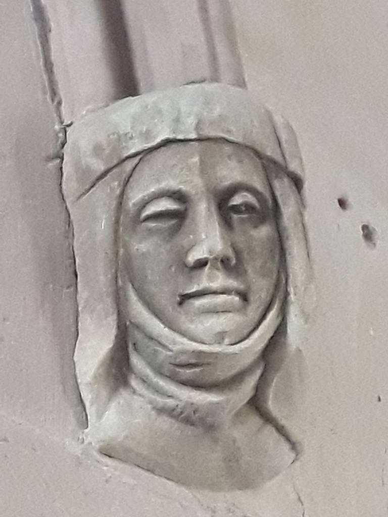
Last stop was Wenlock Priory, a nostalgic journey, back to a place I had not visited since I was a young girl. I was raised in Birmingham and used to come here with my mother in addition to Much Wenlock and Iron Bridge. I have vivid memories of me sitting on part of a ruined wall at the priory. But, this spot I could not find, the memory ‘oft’ plays tricks

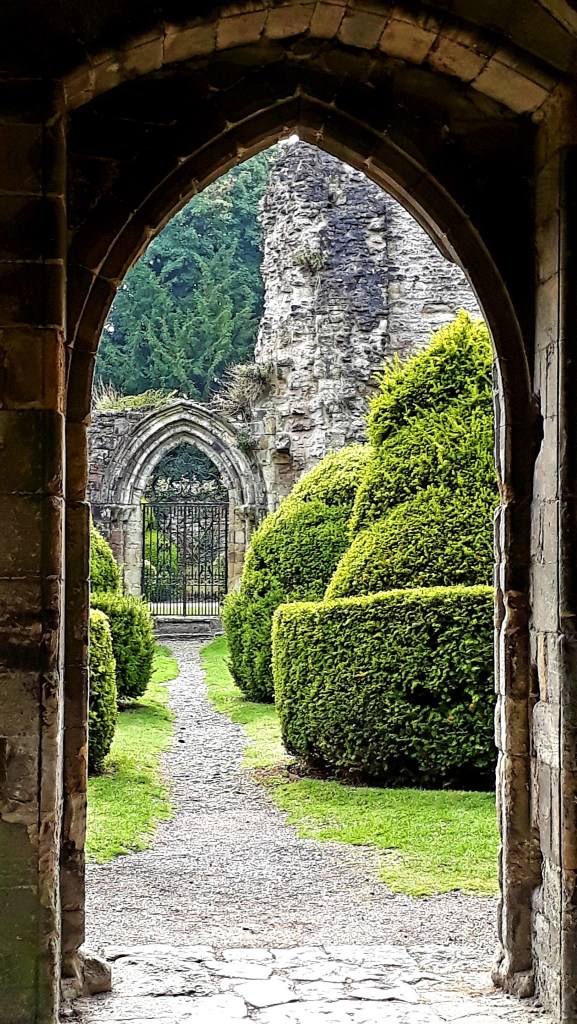

Before heading home, I walked into Much Wenlock town for lunch in the historic square. Try as I might it didn’t evoke any feelings of nostalgia, perhaps too much had changed?
Fortified with coffee and food, I drove the last long stretch, down the M5 and A30 5.5 hrs, straight to my local beach. I swam in boisterous Cornish seas, with another mermaid, and watched a huge orange moon rise over the bay before heading home.
I’d heard of all the storms whilst away, but I wasn’t prepared for the mess on my return. My huge hollyhocks had been blown over, barring entrance to my front door. Even my home doesn’t want me to return to this prison lifestyle.
After hacking my way in and climbing over a pile of mail, I sought out my bed, fell into a deep sleep and dreamed of mountains, freedom and wild places…
Thank you for travelling with me… until the next adventure…
If you enjoyed this blog please consider buying me a coffee, thank you xx

Leave a comment